 Filter: Categories of Wisconsin Historical Images
Filter: County of Ozaukee
Filter: Subject of transportation
Filter: Year of 1800-1899
Filter: Categories of Wisconsin Historical Images
Filter: County of Ozaukee
Filter: Subject of transportation
Filter: Year of 1800-1899

| Date: | 1882 |
|---|---|
| Description: | This map of Cedarburg is a bird's-eye map with an inset of Cedarburg Brewery. Relief is shown pictorially and the map includes an index to buildings. |
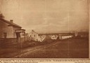
| Date: | 1850 |
|---|---|
| Description: | Main Street in Cedarburg. Includes text which reads: "Cedarburg, Wis., in the year 1850, showing Main Street as it appeared at that time. The photograph wa... |
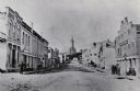
| Date: | 1884 |
|---|---|
| Description: | A distant view of St. Mary's Church. Looking north from the corner of Main and Franklin Streets. |

| Date: | 1876 |
|---|---|
| Description: | This map shows existing and proposed harbor improvements, streets, the Sauk River, and Lake Michigan. On the bottom of the map inscribed in ink is: "44th C... |
If you didn't find the material you searched for, our Library Reference Staff can help.
Call our reference desk at 608-264-6535 or email us at:
