 Filter: Categories of Wisconsin Historical Images
Filter: County of Ozaukee
Filter: Subject of transportation
Filter: Subject of botany
Filter: Categories of Wisconsin Historical Images
Filter: County of Ozaukee
Filter: Subject of transportation
Filter: Subject of botany
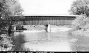
| Date: | 1940 |
|---|---|
| Description: | Exterior view of the last covered bridge in Wisconsin. Caption reads: "Covered Bridge Near Cedarburg, Wis." |

| Date: | 1882 |
|---|---|
| Description: | This map of Cedarburg is a bird's-eye map with an inset of Cedarburg Brewery. Relief is shown pictorially and the map includes an index to buildings. |

| Date: | 2007 |
|---|---|
| Description: | This map of Cedarbug is a bird's-eye map with 8 inset views and an index. The map is a print out of the original map dated 1892 held at the Cedarburg Cultu... |
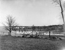
| Date: | |
|---|---|
| Description: | View across field towards the railroad bridge, seen with the construction almost completed. A man is standing in the middle of the bridge, and two or three... |
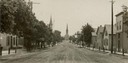
| Date: | 1907 |
|---|---|
| Description: | View down center of unpaved street in Cedarburg, with a large church at the far end. |
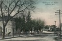
| Date: | 1905 |
|---|---|
| Description: | North view down Washington Avenue. Caption reads: "'Washington Ave., North' Cedarburg Wis." |
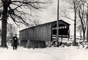
| Date: | 1934 |
|---|---|
| Description: | Southwest view of a covered bridge over Cedar Creek, with a man walking in the snow nearby. |
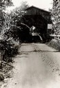
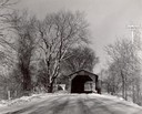
| Date: | 1933 |
|---|---|
| Description: | View down dirt road towards the covered bridge over Cedar Creek, south approach. |
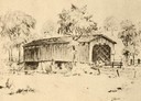
| Date: | 1940 |
|---|---|
| Description: | Drawing of a covered bridge in Cedarburg. |
| Date: | 1940 |
|---|---|
| Description: | Last covered bridge to remain standing in Wisconsin. In the distance an automobile is parked on the side of the road in the shade of a tree. Caption along ... |
| Date: | 1957 |
|---|---|
| Description: | Covered bridge over Cedar Creek in Ozaukee County on highway, about one mile north of Cedarburg. The last remaining covered bridge in Wisconsin. Snow is on... |
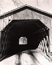
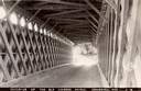
| Date: | 1957 |
|---|---|
| Description: | View through the covered bridge over Cedar Creek in Ozaukee County on highway, about one mile north of Cedarburg. The last remaining covered bridge in Wisc... |
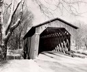
| Date: | 1957 |
|---|---|
| Description: | Covered bridge over Cedar Creek in Ozaukee County on highway, about one mile north of Cedarburg. The last remaining covered bridge in Wisconsin. Snow is on... |
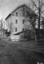
| Date: | 1934 |
|---|---|
| Description: | Exterior of Concordia Mills, once a grain/grist mill. |
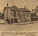
| Date: | 1966 |
|---|---|
| Description: | House on Grand Avenue, built about 1836. "Few people who drive by this house on Port Washington's Grand Avenue daily realize that it is possibly the city's... |
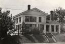
| Date: | 1935 |
|---|---|
| Description: | View of the Blake House (north elevation, front). The house was razed prior to 1952. |

| Date: | 2008 |
|---|---|
| Description: | This contemporary station and convenience store was built in 2004 but harkens back to the early decades of the twentieth century when communities pressured... |
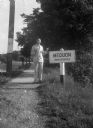
| Date: | |
|---|---|
| Description: | Harold Gauer, wearing a suit and bow tie, and holding an ice cream cone, stands smiling next to a sign on the shoulder of a road that reads "Mequon / Uninc... |
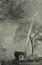
| Date: | 1967 |
|---|---|
| Description: | Worker spraying Elm trees with DDT pumped from a tank hitched to the back of a vehicle equipped with a snow plow. |
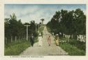
| Date: | |
|---|---|
| Description: | Well-dressed group of three women and one man walking along a dirt road lined with fences and telephone poles. Caption reads: "A Stroll through Donges Bay.... |
If you didn't find the material you searched for, our Library Reference Staff can help.
Call our reference desk at 608-264-6535 or email us at: