Filter: Categories of Wisconsin Historical Images
Filter: County of Ozaukee
Filter: Subject of transportation
Filter: Creator Name of Unknown
Filter: Categories of Wisconsin Historical Images
Filter: County of Ozaukee
Filter: Subject of transportation
Filter: Creator Name of Unknown
| Date: | 1940 |
|---|---|
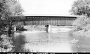
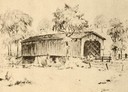
| Description: | Exterior view of the last covered bridge in Wisconsin. Caption reads: "Covered Bridge Near Cedarburg, Wis." |

| Date: | 2007 |
|---|---|
| Description: | This map of Cedarbug is a bird's-eye map with 8 inset views and an index. The map is a print out of the original map dated 1892 held at the Cedarburg Cultu... |
| Date: | |
|---|---|
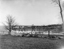
| Description: | View across field towards the railroad bridge, seen with the construction almost completed. A man is standing in the middle of the bridge, and two or three... |
| Date: | 1907 |
|---|---|
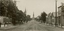
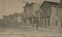
| Description: | View down center of unpaved street in Cedarburg, with a large church at the far end. |
| Date: | 1907 |
|---|---|
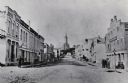
| Description: | View across Washington Avenue. A man is standing in the street near the curb. Caption reads: "Cedarburg, Wis., Washington Avenue looking North." |
| Date: | 1940 |
|---|---|
| Description: | Drawing of a covered bridge in Cedarburg. |
| Date: | 1884 |
|---|---|
| Description: | A distant view of St. Mary's Church. Looking north from the corner of Main and Franklin Streets. |

| Date: | 1915 |
|---|---|
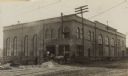
| Description: | View across road towards the Ozaukee County Court House. Caption reads: "Court House, Port Washington, Wis." |
| Date: | 1940 |
|---|---|
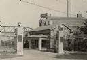
| Description: | A view of the Pebble house, also called Edward Dodge House. Built in 1848 and constructed of cobblestone. Stone columns with a gate and fence are in front ... |

| Date: | 1990 |
|---|---|
| Description: | Director Rupert Wainwright holding a "Dillinger Shot-in-Wisconsin" t-shirt. With him is Dick Matty, secretary of the Wisconsin Department of Tourism, of w... |
| Date: | |
|---|---|
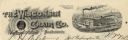
| Description: | Memohead of the Wisconsin Chair Company of Port Washington, Wisconsin, with its McLean patented swing rocking chair set against a circular background with ... |
| Date: | |
|---|---|
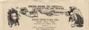
| Description: | Letterhead of the West Side Fuel Company of Port Washington, Wisconsin, with cartoon-style drawings, printed in black ink, of workers mining coal with a pi... |

| Date: | 1961 |
|---|---|
| Description: | This 1961 map of Ozaukee County, Wisconsin, identifies historic sites and landmarks in the county. Cities and villages, roads, and lakes and streams are al... |
| Date: | |
|---|---|
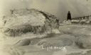
| Description: | View of ice coated pier and lighthouse along the shore of Lake Michigan. Caption reads: "Winter Scene at Port Washington, Wis." |
| Date: | |
|---|---|
| Description: | Postcard view along icy shoreline of the pier and lighthouse on Lake Michigan at Port Washington in winter. |
| Date: | |
|---|---|
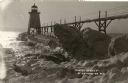
| Description: | Winter postcard view of the pier and lighthouse at Port Washington seen from the icy shore of Lake Michigan. Caption reads: "Light House." |
| Date: | |
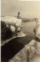
|---|---|
| Description: | Winter view of the lighthouse at Port Washington from the icy shore of Lake Michigan. Two people can be seen standing on a pier in the distance. |
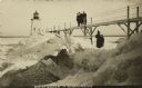
| Date: | 1910 |
|---|---|
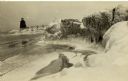
| Description: | Postcard view of three men on an elevated walk on an icy pier near the shoreline. A women and young boy stand on the pier below the walk. There is a lighth... |

| Date: | 1967 |
|---|---|
| Description: | This map of Cedarburg includes a list of historic buildings in the left margin. The map was created by the Ozaukee County Historical Society for Cedarburg'... |
If you didn't find the material you searched for, our Library Reference Staff can help.
Call our reference desk at 608-264-6535 or email us at: