 Filter: Categories of Wisconsin Historical Images
Filter: County of Ozaukee
Filter: Subject of lakes
Filter: Categories of Wisconsin Historical Images
Filter: County of Ozaukee
Filter: Subject of lakes
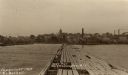
| Date: | 1909 |
|---|---|
| Description: | View down Government Pier. In the distance are industrial buildings along the shoreline. Caption reads: "Gov't Pier Port Washington, Wis." |

| Date: | 1961 |
|---|---|
| Description: | This 1961 map of Ozaukee County, Wisconsin, identifies historic sites and landmarks in the county. Cities and villages, roads, and lakes and streams are al... |

| Date: | |
|---|---|
| Description: | Hand-colored view along shoreline of people posing in a rowboat near a boathouse. Other people are leaning against a railing and standing near a boathouse.... |

| Date: | 1915 |
|---|---|
| Description: | A composite plat map of the towns of Mequon, Saukville, Belgium, Fort Washington, and Fredonia. |

| Date: | 1907 |
|---|---|
| Description: | Handwriting on reverse reads: "Bornstein's boat house (formerly Blommer) and our 3 mile lake created by the dam." Three men are in two rowboats on a lake. ... |
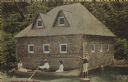
| Date: | 1907 |
|---|---|
| Description: | Text on front reads: "Donges Bay Boat House." A man rowing a boat with two women passengers, in front of a boathouse built of rocks. A lawn jockey stands o... |
If you didn't find the material you searched for, our Library Reference Staff can help.
Call our reference desk at 608-264-6535 or email us at: