 Filter: Categories of Wisconsin Historical Images
Filter: County of Ozaukee
Filter: Subject of hills
Filter: Categories of Wisconsin Historical Images
Filter: County of Ozaukee
Filter: Subject of hills

| Date: | 1882 |
|---|---|
| Description: | This map of Cedarburg is a bird's-eye map with an inset of Cedarburg Brewery. Relief is shown pictorially and the map includes an index to buildings. |
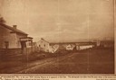
| Date: | 1850 |
|---|---|
| Description: | Main Street in Cedarburg. Includes text which reads: "Cedarburg, Wis., in the year 1850, showing Main Street as it appeared at that time. The photograph wa... |
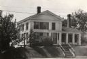
| Date: | 1935 |
|---|---|
| Description: | View of the Blake House (north elevation, front). The house was razed prior to 1952. |

| Date: | |
|---|---|
| Description: | Hand-colored bird's-eye view down the center of a main street in Cedarburg. Horse and buggy traffic is in the street, with dwellings and buildings on the l... |
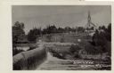
| Date: | 1918 |
|---|---|
| Description: | View of Grafton from across a dam on the Milwaukee River. St. Joseph's Catholic Church is in the distance on a hill. Caption reads: "Scenic View, Grafton, ... |
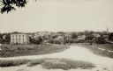
| Date: | 1916 |
|---|---|
| Description: | View of Grafton from the road leading into town. There is a bridge over the river, and a church is on the far right. Caption reads: "Birdseye [sic] View, G... |
If you didn't find the material you searched for, our Library Reference Staff can help.
Call our reference desk at 608-264-6535 or email us at: