 Filter: Categories of Wisconsin Historical Images
Filter: County of Ozaukee
Filter: Subject of botany
Filter: Creator Name of Unknown
Filter: Categories of Wisconsin Historical Images
Filter: County of Ozaukee
Filter: Subject of botany
Filter: Creator Name of Unknown
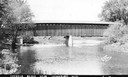
| Date: | 1940 |
|---|---|
| Description: | Exterior view of the last covered bridge in Wisconsin. Caption reads: "Covered Bridge Near Cedarburg, Wis." |

| Date: | 2007 |
|---|---|
| Description: | This map of Cedarbug is a bird's-eye map with 8 inset views and an index. The map is a print out of the original map dated 1892 held at the Cedarburg Cultu... |
| Date: | |
|---|---|
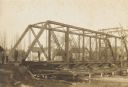
| Description: | View across field towards the railroad bridge, seen with the construction almost completed. A man is standing in the middle of the bridge, and two or three... |
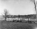
| Date: | 1907 |
|---|---|
| Description: | View down center of unpaved street in Cedarburg, with a large church at the far end. |
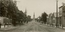
| Date: | 1940 |
|---|---|
| Description: | Drawing of a covered bridge in Cedarburg. |

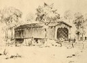
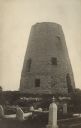
| Date: | 1872 |
|---|---|
| Description: | Wind powered stone grist mill. Two men stand on a wood balcony near the open doorway of the windmill. |
| Date: | 1870 |
|---|---|
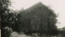
| Description: | Martin H. Meyer's birthplace. Reproduced from a lead pencil sketch made in 1870. |
| Date: | 06 14 1946 |
|---|---|
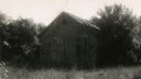
| Description: | View of the school surrounded by trees, out in an overgrown field during a warm season. Stony Hill School house, where the first Flag Day was celebrated on... |
| Date: | 06 14 1946 |
|---|---|
| Description: | Stony Hill School house, where the first Flag Day was celebrated on June 14, 1885. |
| Date: | 1906 |
|---|---|
| Description: | Steel span railroad bridge under construction over Cedar Creek. |

| Date: | 01 09 1958 |
|---|---|
| Description: | Elevated view from bluff of the harbor towards the southeast. At the end of a jetty is a lighthouse on the left. The water is frozen along the shoreline. T... |

| Date: | 01 09 1958 |
|---|---|
| Description: | View of Port Washington Harbor from Wisconsin Electric Power Company wharf. The city is in the background along the shoreline. |
| Date: | 1915 |
|---|---|
| Description: | Photographic postcard view of the old grist mill, with a cemetery in the foreground. Caption reads: "The Old Mill, Cedarburg." |

| Date: | 1915 |
|---|---|
| Description: | Photographic postcard view down unpaved Washington Avenue. A clock on the sidewalk on the left is in front of a musical instrument shop. Snow is on the gro... |

| Date: | 1871 |
|---|---|
| Description: | View toward the church, which is a stone building with a clock in the bell tower/steeple. Arched windows are on the front and sides. A fence is running alo... |

| Date: | 1916 |
|---|---|
| Description: | View of the power house and city hall in Cedarburg. The power house has a smokestack and the city hall has a bell tower. Caption reads: "Power House; City ... |

| Date: | |
|---|---|
| Description: | Photographic postcard view of the Hotel Hilgen Spring with an automobile parked in front. Caption reads: "Hotel Hilgen Spring, Cedarburg, Wis." |
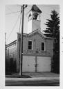
| Date: | 1975 |
|---|---|
| Description: | View across street towards the Waubeka firehouse at 401 Center Street. In a tower above the entrance is the Red Arrow siren, which has since been removed. |

| Date: | 1911 |
|---|---|
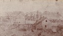
| Description: | View down street with businesses, dwellings and a church. An automobile and a horse-drawn vehicle are parked on the right. Caption reads: "Street Scene, Fr... |

| Date: | 1914 |
|---|---|
| Description: | View down road towards the wooden church with a steeple. This church is located on the west side of the city on the north side of the road. Caption reads: ... |
If you didn't find the material you searched for, our Library Reference Staff can help.
Call our reference desk at 608-264-6535 or email us at: