 Filter: Categories of Wisconsin Historical Images
Filter: County of Ozaukee
Filter: Reproduction Rights of For Sale
Filter: Categories of Wisconsin Historical Images
Filter: County of Ozaukee
Filter: Reproduction Rights of For Sale

| Date: | 1967 |
|---|---|
| Description: | This map of Cedarburg includes a list of historic buildings in the left margin. The map was created by the Ozaukee County Historical Society for Cedarburg'... |
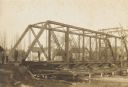
| Date: | 1906 |
|---|---|
| Description: | Steel span railroad bridge under construction over Cedar Creek. |

| Date: | 1938 |
|---|---|
| Description: | This map shows plat of town, boundary lines of assessors blocks, land ownership by name, local streets, railroads, wards, lots, and parts of Cedar Creek. T... |

| Date: | |
|---|---|
| Description: | View down center of downtown street in Port Washington. Night view showing electric lights, neon signs and falling snowflakes. |

| Date: | 1910 |
|---|---|
| Description: | Catalog cover for Gasoline Engines, Types T. Z. Y. W. "Goes like sixty." |
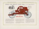
| Date: | 1910 |
|---|---|
| Description: | Inside spread of catalog, featuring a color illustration of a portable engine. Text reads: "Gilson 100% Service Portable Engine — 4, 5, 6 and 8 H.P." Inset... |

| Date: | 1910 |
|---|---|
| Description: | Front page of Gilson Manufacturing Company brochure, with the title: "The engine that saves the wheat." Features an image of two men using the attachment i... |

| Date: | 1876 |
|---|---|
| Description: | This map shows existing and proposed harbor improvements, streets, the Sauk River, and Lake Michigan. On the bottom of the map inscribed in ink is: "44th C... |

| Date: | 01 09 1958 |
|---|---|
| Description: | Elevated view from bluff of the harbor towards the southeast. At the end of a jetty is a lighthouse on the left. The water is frozen along the shoreline. T... |

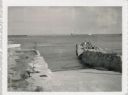
| Date: | 01 09 1958 |
|---|---|
| Description: | View of Port Washington Harbor from Wisconsin Electric Power Company wharf. The city is in the background along the shoreline. |
| Date: | 07 27 1960 |
|---|---|
| Description: | View from shoreline at Port Washington south of two ramps within a breakwater. There is a lighthouse in the background. Boats are along a pier on the right... |

| Date: | 1989 |
|---|---|
| Description: | This pictorial map shows Lake Michigan, businesses with phone numbers, schools, parks, other points of interest, and includes a brief history of the town. ... |

| Date: | 1960 |
|---|---|
| Description: | This blue line print map shows zone districts, lot and block numbers and dimensions, building setbacks, center lines of streets, and some landownership. Th... |
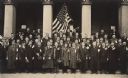
| Date: | 1917 |
|---|---|
| Description: | Group of WWI draftees assembled in front of the Ozaukee County Courthouse. In the background a man is holding up a flag between the center columns of the b... |
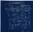
| Date: | 04 1958 |
|---|---|
| Description: | This blueprint map shows additions, sections, and streets. The upper left of the map reads: "Plan for 6ʺ watermain, hydrants & appurtenances." The up... |
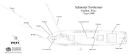
| Date: | 08 2009 |
|---|---|
| Description: | Archaeological overhead view site plan of the schooner Northerner. Labels indicate various parts of the ship that remain. On the left is a map scale... |

| Date: | 1962 |
|---|---|
| Description: | View from side of road towards the covered bridge, with the historical marker on the right. "This bridge was built by the town of Cedarburg on petition of ... |
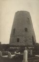
| Date: | 1915 |
|---|---|
| Description: | Photographic postcard view of the old grist mill, with a cemetery in the foreground. Caption reads: "The Old Mill, Cedarburg." |

| Date: | |
|---|---|
| Description: | Hand-colored bird's-eye view down the center of a main street in Cedarburg. Horse and buggy traffic is in the street, with dwellings and buildings on the l... |

| Date: | |
|---|---|
| Description: | Hand-colored elevated view of a residential neighborhood in Cedarburg. There is a church in the background on the left. Caption reads: "Birds [sic] Eye Vie... |
If you didn't find the material you searched for, our Library Reference Staff can help.
Call our reference desk at 608-264-6535 or email us at: