 Filter: Categories of Wisconsin Historical Images
Filter: County of Outagamie
Filter: Categories of Wisconsin Historical Images
Filter: County of Outagamie

| Date: | 1889 |
|---|---|
| Description: | Mrs. Cadle seated in a bedroom, looking out a window. On the table in front of her is a cup and saucer. |

| Date: | 1960 |
|---|---|
| Description: | This map shows a plat of the city, wards, lots, local streets, roads, railroads, buildings, parks, and part of Fox River. The map includes tables for plat ... |
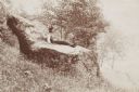
| Date: | 1895 |
|---|---|
| Description: | Young man sitting on a large rock called the “Devil's Chair” in Rattlesnake Hollow. |

| Date: | 1890 |
|---|---|
| Description: | This map is a plat map and shows government buildings, churches, Klein’s Park, and the government dam in Kaukauna. The map includes text about Kaukauna wit... |

| Date: | 1852 |
|---|---|
| Description: | This map shows plat of three towns, sections, local streets, the Grand Chute Island, and part of the Fox River. The map includes 1 inset map: "Diagram of C... |

| Date: | 1968 |
|---|---|
| Description: | This map shows local streets, wards, buildings, parks, and part of the Fox River. The map is also indexed by street name. Ward borders and numbering and th... |

| Date: | 1960 |
|---|---|
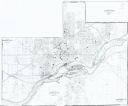
| Description: | This map shows local streets, wards, public buildings, parks, and part of the Fox River. The land is shown in white and the water is shown in blue. The map... |
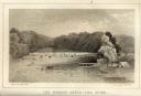
| Date: | 1856 |
|---|---|
| Description: | Lithographic view of the Grande Chute Falls on the Fox River. There is a tent on the shore on the right. |

| Date: | 1945 |
|---|---|
| Description: | Photographic postcard view from street of the Standard Service Station, with cars parked along the curb, and another car at a pump. The building to the lef... |
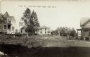
| Date: | 1910 |
|---|---|
| Description: | Photographic postcard of wooden, two-story houses on curved road. Two small trees are in front of the house on the left. There is a grassy area in the fore... |
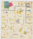
| Date: | 1900 |
|---|---|
| Description: | A Sanborn map of a portion of Seymour, Wisconsin. |
| Date: | 1949 |
|---|---|
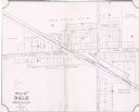
| Description: | This map is ink and pencil on paper and shows land ownership by name, years of purchase, and city limits. Also included on the right and bottom margins are... |

| Date: | 1891 |
|---|---|
| Description: | This blueprint manuscript map shows land owned by Green Bay & Mississippi Canal Co., Meade, Vilas, Patten, and Hewitt. Streets and the Fox River are labele... |

| Date: | 1891 |
|---|---|
| Description: | This blueprint manuscript map shows land owned by Kaukauna Water Power Co., Green Bay & Mississippi Canal Co., A.W. Patten, N.M. Edwards, and M.J. Meade. P... |

| Date: | 1947 |
|---|---|
| Description: | View from hill looking down across fields at the property of Charles Grignon. Grignon Mansion in the background among trees, and beyond is the Fox River. O... |
| Date: | 1904 |
|---|---|
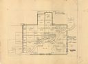
| Description: | This map shows land parcels, street names, and school locations, and potential land additions to the town. The Wisconsin Central Railroad is labeled. |
| Date: | 1985 |
|---|---|
| Description: | This photocopied map shows the area as it appeared in 1889. The map shows buildings, lot numbers, some landownership, and the Fox River. |
| Date: | 1930 |
|---|---|
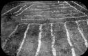
| Description: | Raised linear garden beds have been delineated with hydrated lime to show the arrangement of the intersecting beds. |

| Date: | 1930 |
|---|---|
| Description: | A map of the site of a Native American village with a complex of linear raised garden beds and cache pits near Leeman. Also shown are a farmstead, road, an... |
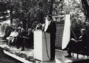
| Date: | 06 15 1965 |
|---|---|
| Description: | Leslie Fishel, Director of the State Historical Society of Wisconsin, speaking from the stage at the dedication and unveiling of the Milwaukee-Downer Colle... |
If you didn't find the material you searched for, our Library Reference Staff can help.
Call our reference desk at 608-264-6535 or email us at: