Filter: Categories of Wisconsin Historical Images
Filter: County of Outagamie
Filter: Categories of Wisconsin Historical Images
Filter: County of Outagamie
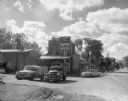
| Date: | 1960 |
|---|---|
| Description: | A Wisconsin State Canners Truck parked under a chute at Stokely Van Camp canning factory on West College Avenue. |
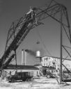
| Date: | 1960 |
|---|---|
| Description: | Exterior of Olsen's Mill (Wayne Feeds) on Hwy 49, just north of Hwy 21. |
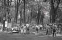
| Date: | 1955 |
|---|---|
| Description: | Prospective buyers examine artwork at an art fair at City Park. |
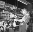
| Date: | 1970 |
|---|---|
| Description: | A shoemaker repairs the sole of a boot using a sewing machine. |
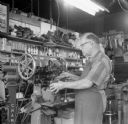
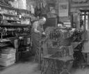
| Date: | 1970 |
|---|---|
| Description: | A shoemaker repairs the sole of a boot using a sewing machine. |

| Date: | 1955 |
|---|---|
| Description: | Louie Suttner inspecting the wheat crop at his farm, the current site of the Fox River Mall. |

| Date: | 1960 |
|---|---|
| Description: | Louis Suttner and another man making apple cider. |
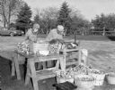
| Date: | 1960 |
|---|---|
| Description: | Louis Suttner and another man make apple cider outdoors. |

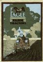
| Date: | 1919 |
|---|---|
| Description: | Front cover of a pamphlet advertising Eagle farm tractors. Features an illustration of an eagle and a photograph of a man using a tractor in a field. |

| Date: | 1920 |
|---|---|
| Description: | Front cover of a pamphlet advertising the Eagle steel frame silo filler featuring a color illustration of two farmers using the filler. |
| Date: | 1920 |
|---|---|
| Description: | Front cover of a booklet advertising Eagle farm tractors featuring a color illustration of a man using a tractor to plow a field in front of a farmhouse. |

| Date: | 1898 |
|---|---|
| Description: | This 1898 map of Outagamie County, Wisconsin, shows the township and range grid, towns, sections, cities and villages, the Oneida Reservation, landownershi... |

| Date: | 1903 |
|---|---|
| Description: | This 1903 map of Outagamie County, Wisconsin, shows the township and range grid, towns, sections, cities and villages, landownership and acreages, rural ma... |

| Date: | |
|---|---|
| Description: | This 1907 map of Outagamie County, Wisconsin, shows the township and range grid, towns, sections, cities and villages, railroads, wagon roads, churches, sc... |

| Date: | 1922 |
|---|---|
| Description: | This map of Outagamie County, Wisconsin, from the first half of the 20th century, shows the township and range grid, towns, sections, cities and villages, ... |
| Date: | |
|---|---|
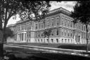
| Description: | Exterior view of Appleton High School. Caption reads: "High School - Appleton, Wis." |
| Date: | |
|---|---|
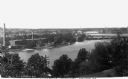
| Description: | Elevated view of hydroelectric plants on the Fox River. Caption reads: "Water Power - Looking West. Appleton, Wis." |
| Date: | |
|---|---|
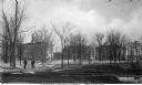
| Description: | View of Lawrence University campus. Two men stand on the sidewalk in the foreground. Caption reads: "Lawrence University Campus, Appleton, Wis." |
If you didn't find the material you searched for, our Library Reference Staff can help.
Call our reference desk at 608-264-6535 or email us at: