 Filter: Categories of Wisconsin Historical Images
Filter: County of Outagamie
Filter: Year of 1900-1999
Filter: Subject of cities and towns
Filter: Categories of Wisconsin Historical Images
Filter: County of Outagamie
Filter: Year of 1900-1999
Filter: Subject of cities and towns

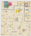
| Date: | 1916 |
|---|---|
| Description: | Map shows roads, railroads, the Fox River, parks, and cemeteries. Wards are numbered and the edges of the map feature coordinates. The top left of the map ... |

| Date: | 1921 |
|---|---|
| Description: | Map reads: "1918. Revised 1921." Key to the map in upper right hand corner reads: "Residential Districts," "Local Businesses," "Commercial and Light Manufa... |

| Date: | 1931 |
|---|---|
| Description: | Map shows street map with wards numbered, the Fox River, railroads, playgrounds, cemeteries, and schools. The map also includes a manuscript annotation ind... |

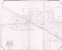
| Date: | 01 1940 |
|---|---|
| Description: | Map shows roads, railroads, the Fox River, parks, schools, and cemeteries and is indexed by street name in the margins. The bottom of the map show the Winn... |

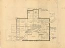
| Date: | 04 1956 |
|---|---|
| Description: | Map includes an index for building locations on the Lawrence University campus in the upper right hand corner. Map shows roads, rivers, campus buildings by... |

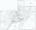
| Date: | 1957 |
|---|---|
| Description: | Map is indexed by street name in the margins. The map shows roads, highways, railroads, parks, city buildings, schools, cemeteries, city limits, and the Fo... |
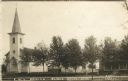
| Date: | 1913 |
|---|---|
| Description: | Photographic postcard view of a town block with a church and two houses along a tree-lined street. Two young children are standing on the sidewalk. Caption... |
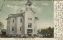
| Date: | 1909 |
|---|---|
| Description: | Exterior view of a school. Students and teachers are gathered in front. Caption reads: "Public School, Black Creek, Wis." |

| Date: | 1960 |
|---|---|
| Description: | This map shows a plat of the city, wards, lots, local streets, roads, railroads, buildings, parks, and part of Fox River. The map includes tables for plat ... |

| Date: | 1968 |
|---|---|
| Description: | This map shows local streets, wards, buildings, parks, and part of the Fox River. The map is also indexed by street name. Ward borders and numbering and th... |

| Date: | 1960 |
|---|---|
| Description: | This map shows local streets, wards, public buildings, parks, and part of the Fox River. The land is shown in white and the water is shown in blue. The map... |
| Date: | 1900 |
|---|---|
| Description: | A Sanborn map of a portion of Seymour, Wisconsin. |
| Date: | 1949 |
|---|---|
| Description: | This map is ink and pencil on paper and shows land ownership by name, years of purchase, and city limits. Also included on the right and bottom margins are... |
| Date: | 1904 |
|---|---|
| Description: | This map shows land parcels, street names, and school locations, and potential land additions to the town. The Wisconsin Central Railroad is labeled. |
| Date: | 1985 |
|---|---|
| Description: | This photocopied map shows the area as it appeared in 1889. The map shows buildings, lot numbers, some landownership, and the Fox River. |

| Date: | 1908 |
|---|---|
| Description: | Exterior view of the public library, with a gable above the entrance. Caption reads: "Public Library, Kaukauna, Wis." |

| Date: | 1913 |
|---|---|
| Description: | Exterior view of a gothic-style church with two steeples, and a clock tower in the taller steeple. A rose window is above the entrance. Caption reads: "Hol... |

| Date: | 1905 |
|---|---|
| Description: | Elevated view towards the nave and the altar of St. Mary's Church. Caption reads: "Interior of St. Mary's Church, South Kaukauna, Wis." |
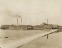
| Date: | 1922 |
|---|---|
| Description: | View across water, rushing over a dam, towards the Kimberly Paper Mill. |
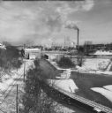
| Date: | 02 1951 |
|---|---|
| Description: | Elevated view of the Fox River Valley from Memorial Drive bridge, looking East. Snow is on the ground, ice is on the river and the smokestacks are billowin... |
If you didn't find the material you searched for, our Library Reference Staff can help.
Call our reference desk at 608-264-6535 or email us at: