 Filter: Categories of Wisconsin Historical Images
Filter: County of Outagamie
Filter: Year of 1800-1899
Filter: Categories of Wisconsin Historical Images
Filter: County of Outagamie
Filter: Year of 1800-1899

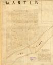
| Date: | 1873 |
|---|---|
| Description: | Map shows townships and sections, landownership and acreages, state and county lands, churches, schools, cemeteries, roads, and railroads. There is an inse... |
| Date: | 1800 |
|---|---|
| Description: | Ink and pencil on paper. A paper city on the site of what is now Appleton, Wisconsin. Shows plat of city, streets, and Fox River. Includes textual descript... |

| Date: | 1874 |
|---|---|
| Description: | Bird's-eye view map of Appleton, Wisconsin. Map reads: "NOTE.-Since the above cut was engraved, the Fox River Pulp & Paper Co.'s Mammoth Mills have been er... |

| Date: | 1886 |
|---|---|
| Description: | Posed group portrait of men and women members of the “Class of '86” at Lawrence College. The 8 men have silk top hats and the 4 women have umbrellas, for a... |

| Date: | 1889 |
|---|---|
| Description: | Mrs. Cadle seated in a bedroom, looking out a window. On the table in front of her is a cup and saucer. |
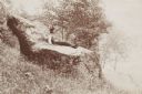
| Date: | 1895 |
|---|---|
| Description: | Young man sitting on a large rock called the “Devil's Chair” in Rattlesnake Hollow. |

| Date: | 1890 |
|---|---|
| Description: | This map is a plat map and shows government buildings, churches, Klein’s Park, and the government dam in Kaukauna. The map includes text about Kaukauna wit... |

| Date: | 1852 |
|---|---|
| Description: | This map shows plat of three towns, sections, local streets, the Grand Chute Island, and part of the Fox River. The map includes 1 inset map: "Diagram of C... |
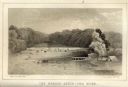
| Date: | 1856 |
|---|---|
| Description: | Lithographic view of the Grande Chute Falls on the Fox River. There is a tent on the shore on the right. |

| Date: | 1891 |
|---|---|
| Description: | This blueprint manuscript map shows land owned by Green Bay & Mississippi Canal Co., Meade, Vilas, Patten, and Hewitt. Streets and the Fox River are labele... |

| Date: | 1891 |
|---|---|
| Description: | This blueprint manuscript map shows land owned by Kaukauna Water Power Co., Green Bay & Mississippi Canal Co., A.W. Patten, N.M. Edwards, and M.J. Meade. P... |

| Date: | 1870 |
|---|---|
| Description: | This blue line print covers the stretch of railroad numbered 1478+40 through 1689+60. Some streets and blocks in the town and the Wolf River are labeled. |

| Date: | 1874 |
|---|---|
| Description: | Birds-eye view of Appleton Wisconsin. In the foreground are people fishing, strolling, and looking over the canal towards the Fox River. Streets and buildi... |

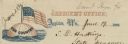
| Date: | 01 03 1863 |
|---|---|
| Description: | Letterhead of a bald eagle perched on top of a drum and holding arrows in its talons. There is an olive branch on the ground next to loose cannon balls and... |
| Date: | 06 19 1862 |
|---|---|
| Description: | Letterhead of a globe floating in the ocean. The text: "Our Country" is printed onto the globe. The American flag is flying from the top of the globe. Text... |
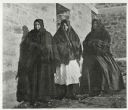
| Date: | 1899 |
|---|---|
| Description: | Group portrait of three women standing outside against a brick building. All three women are wearing dresses, with shawls covering their shoulders and head... |

| Date: | 1896 |
|---|---|
| Description: | View down street towards the George Walter Brewing Company. A large group of people are posing on the street with horse-drawn carriages and horse-drawn wag... |
If you didn't find the material you searched for, our Library Reference Staff can help.
Call our reference desk at 608-264-6535 or email us at: