 Filter: Categories of Wisconsin Historical Images
Filter: County of Outagamie
Filter: Subject of transportation
Filter: Categories of Wisconsin Historical Images
Filter: County of Outagamie
Filter: Subject of transportation

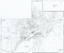
| Date: | 1968 |
|---|---|
| Description: | This map shows local streets, wards, buildings, parks, and part of the Fox River. The map is also indexed by street name. Ward borders and numbering and th... |

| Date: | 1960 |
|---|---|
| Description: | This map shows local streets, wards, public buildings, parks, and part of the Fox River. The land is shown in white and the water is shown in blue. The map... |
| Date: | 1856 |
|---|---|
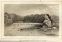
| Description: | Lithographic view of the Grande Chute Falls on the Fox River. There is a tent on the shore on the right. |

| Date: | 1945 |
|---|---|
| Description: | Photographic postcard view from street of the Standard Service Station, with cars parked along the curb, and another car at a pump. The building to the lef... |
| Date: | 1910 |
|---|---|
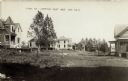
| Description: | Photographic postcard of wooden, two-story houses on curved road. Two small trees are in front of the house on the left. There is a grassy area in the fore... |
| Date: | 1900 |
|---|---|
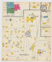
| Description: | A Sanborn map of a portion of Seymour, Wisconsin. |

| Date: | 1891 |
|---|---|
| Description: | This blueprint manuscript map shows land owned by Green Bay & Mississippi Canal Co., Meade, Vilas, Patten, and Hewitt. Streets and the Fox River are labele... |

| Date: | 1891 |
|---|---|
| Description: | This blueprint manuscript map shows land owned by Kaukauna Water Power Co., Green Bay & Mississippi Canal Co., A.W. Patten, N.M. Edwards, and M.J. Meade. P... |
| Date: | 1904 |
|---|---|
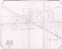
| Description: | This map shows land parcels, street names, and school locations, and potential land additions to the town. The Wisconsin Central Railroad is labeled. |
| Date: | 1985 |
|---|---|
| Description: | This photocopied map shows the area as it appeared in 1889. The map shows buildings, lot numbers, some landownership, and the Fox River. |

| Date: | 1930 |
|---|---|
| Description: | A map of the site of a Native American village with a complex of linear raised garden beds and cache pits near Leeman. Also shown are a farmstead, road, an... |

| Date: | 1870 |
|---|---|
| Description: | This blue line print covers the stretch of railroad numbered 1478+40 through 1689+60. Some streets and blocks in the town and the Wolf River are labeled. |

| Date: | 1874 |
|---|---|
| Description: | Birds-eye view of Appleton Wisconsin. In the foreground are people fishing, strolling, and looking over the canal towards the Fox River. Streets and buildi... |
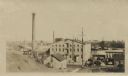
| Date: | |
|---|---|
| Description: | Elevated view from hill of the Atlas Paper Mill owned by the Kimberly Clark Paper Company. |
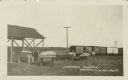
| Date: | 1909 |
|---|---|
| Description: | View across field towards men loading carts of cabbage onto boxcars. Caption reads: "Shipping Cabbage, Greenville, Wis." |
| Date: | |
|---|---|
| Description: | Colorized postcard view down center of Main Street, which is lined with businesses. There are horse-drawn vehicles in the street. Caption reads: "Main Stre... |
| Date: | |
|---|---|
| Description: | Elevated view of a row of businesses along the Fox River near the dam. There are horse-drawn vehicles in the street. Advertisements are on the side of the ... |

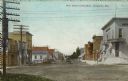
| Date: | |
|---|---|
| Description: | View of the businesses lining Second Street. There is a horse and wagon at the curb, and boys are standing in the street. Caption reads: "Second Street, Ka... |

| Date: | |
|---|---|
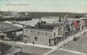
| Description: | Elevated view of Kaukauna's south side, with the north side in the distance. There is a bridge over the Fox River. Caption reads: "Looking North from South... |
| Date: | |
|---|---|
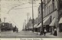
| Description: | View looking up street towards the businesses along Wisconsin Avenue. There are cable car tracks running up the street, and a bank is on the corner. Pedest... |
If you didn't find the material you searched for, our Library Reference Staff can help.
Call our reference desk at 608-264-6535 or email us at: