 Filter: Categories of Wisconsin Historical Images
Filter: County of Outagamie
Filter: Subject of transportation
Filter: Categories of Wisconsin Historical Images
Filter: County of Outagamie
Filter: Subject of transportation

| Date: | 1903 |
|---|---|
| Description: | This 1903 map of Outagamie County, Wisconsin, shows the township and range grid, towns, sections, cities and villages, landownership and acreages, rural ma... |

| Date: | |
|---|---|
| Description: | This 1907 map of Outagamie County, Wisconsin, shows the township and range grid, towns, sections, cities and villages, railroads, wagon roads, churches, sc... |

| Date: | 1922 |
|---|---|
| Description: | This map of Outagamie County, Wisconsin, from the first half of the 20th century, shows the township and range grid, towns, sections, cities and villages, ... |

| Date: | |
|---|---|
| Description: | Exterior view of Appleton High School. Caption reads: "High School - Appleton, Wis." |
| Date: | |
|---|---|
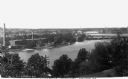
| Description: | Elevated view of hydroelectric plants on the Fox River. Caption reads: "Water Power - Looking West. Appleton, Wis." |
| Date: | 1927 |
|---|---|
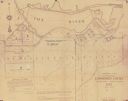
| Description: | Shows landowner's lots, roads, railroads, and Fox River. Also includes certificate of survey text. Includes significant manuscript annotations depicting th... |
| Date: | |
|---|---|
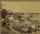
| Description: | Elevated view of a lock at Appleton, with views of mills and other structures in the background. |

| Date: | 1873 |
|---|---|
| Description: | Map shows townships and sections, landownership and acreages, state and county lands, churches, schools, cemeteries, roads, and railroads. There is an inse... |

| Date: | 1952 |
|---|---|
| Description: | Map shows roads, highways, railroads, parks, city buildings, schools, cemeteries, city limits, and the Fox River. The map is indexed by street name, street... |
| Date: | 1800 |
|---|---|
| Description: | Ink and pencil on paper. A paper city on the site of what is now Appleton, Wisconsin. Shows plat of city, streets, and Fox River. Includes textual descript... |

| Date: | 1874 |
|---|---|
| Description: | Bird's-eye view map of Appleton, Wisconsin. Map reads: "NOTE.-Since the above cut was engraved, the Fox River Pulp & Paper Co.'s Mammoth Mills have been er... |

| Date: | 1916 |
|---|---|
| Description: | Map shows roads, railroads, the Fox River, parks, and cemeteries. Wards are numbered and the edges of the map feature coordinates. The top left of the map ... |

| Date: | 1921 |
|---|---|
| Description: | Map reads: "1918. Revised 1921." Key to the map in upper right hand corner reads: "Residential Districts," "Local Businesses," "Commercial and Light Manufa... |

| Date: | 1931 |
|---|---|
| Description: | Map shows street map with wards numbered, the Fox River, railroads, playgrounds, cemeteries, and schools. The map also includes a manuscript annotation ind... |

| Date: | 01 1940 |
|---|---|
| Description: | Map shows roads, railroads, the Fox River, parks, schools, and cemeteries and is indexed by street name in the margins. The bottom of the map show the Winn... |

| Date: | 1957 |
|---|---|
| Description: | Map is indexed by street name in the margins. The map shows roads, highways, railroads, parks, city buildings, schools, cemeteries, city limits, and the Fo... |
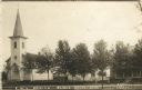
| Date: | 1913 |
|---|---|
| Description: | Photographic postcard view of a town block with a church and two houses along a tree-lined street. Two young children are standing on the sidewalk. Caption... |

| Date: | 1960 |
|---|---|
| Description: | This map shows a plat of the city, wards, lots, local streets, roads, railroads, buildings, parks, and part of Fox River. The map includes tables for plat ... |

| Date: | 1890 |
|---|---|
| Description: | This map is a plat map and shows government buildings, churches, Klein’s Park, and the government dam in Kaukauna. The map includes text about Kaukauna wit... |

| Date: | 1852 |
|---|---|
| Description: | This map shows plat of three towns, sections, local streets, the Grand Chute Island, and part of the Fox River. The map includes 1 inset map: "Diagram of C... |
If you didn't find the material you searched for, our Library Reference Staff can help.
Call our reference desk at 608-264-6535 or email us at: