 Filter: Categories of Wisconsin Historical Images
Filter: County of Outagamie
Filter: Subject of school buildings
Filter: Categories of Wisconsin Historical Images
Filter: County of Outagamie
Filter: Subject of school buildings

| Date: | 1905 |
|---|---|
| Description: | View across street toward the school. Caption reads: "Lincoln School, Appleton, Wis." |
| Date: | 1905 |
|---|---|
| Description: | Exterior view school, partly obscured by trees. Caption reads: "Sixth Ward School, Appleton, Wis." |
| Date: | 04 1978 |
|---|---|
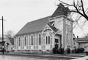
| Description: | Temple Zion and the adjacent school. At this time Temple Zion was used as the Outagamie Historical Society. |
| Date: | 1910 |
|---|---|
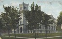
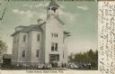
| Description: | View across lawn toward the school. Caption reads: "High school, Little Chute, Wis." |
| Date: | 1910 |
|---|---|
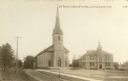
| Description: | St. John's Church and school. Caption reads: "St. John's Church & School, Little Chute, Wis." |

| Date: | 1915 |
|---|---|
| Description: | Class group portrait of Joseph R. McCarthy's grade school classmates. McCarthy is in the center of the group. McCarthy dropped out of school at age 14. |

| Date: | |
|---|---|
| Description: | Exterior view from across street of Lincoln School, which opened in 1898. A wide lawn leads to the building's arched entrance and central pavilion. Captio... |
| Date: | |
|---|---|
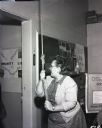
| Description: | Teacher pulling on a rope to ring the school bell in a one-room school house. School literature and a chalkboard are visible in the background. |
| Date: | |
|---|---|
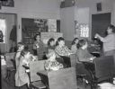
| Description: | Class of young boys and girls in a one-room school house. The children sit in three rows of school desks, watching their teacher as she instructs. Books an... |
| Date: | |
|---|---|
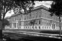
| Description: | Exterior view of Appleton High School. Caption reads: "High School - Appleton, Wis." |

| Date: | 1873 |
|---|---|
| Description: | Map shows townships and sections, landownership and acreages, state and county lands, churches, schools, cemeteries, roads, and railroads. There is an inse... |

| Date: | 1952 |
|---|---|
| Description: | Map shows roads, highways, railroads, parks, city buildings, schools, cemeteries, city limits, and the Fox River. The map is indexed by street name, street... |

| Date: | 1874 |
|---|---|
| Description: | Bird's-eye view map of Appleton, Wisconsin. Map reads: "NOTE.-Since the above cut was engraved, the Fox River Pulp & Paper Co.'s Mammoth Mills have been er... |

| Date: | 1931 |
|---|---|
| Description: | Map shows street map with wards numbered, the Fox River, railroads, playgrounds, cemeteries, and schools. The map also includes a manuscript annotation ind... |

| Date: | 01 1940 |
|---|---|
| Description: | Map shows roads, railroads, the Fox River, parks, schools, and cemeteries and is indexed by street name in the margins. The bottom of the map show the Winn... |

| Date: | 1957 |
|---|---|
| Description: | Map is indexed by street name in the margins. The map shows roads, highways, railroads, parks, city buildings, schools, cemeteries, city limits, and the Fo... |
| Date: | 1909 |
|---|---|
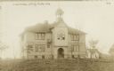
| Description: | Exterior view of a school. Students and teachers are gathered in front. Caption reads: "Public School, Black Creek, Wis." |

| Date: | 1874 |
|---|---|
| Description: | Birds-eye view of Appleton Wisconsin. In the foreground are people fishing, strolling, and looking over the canal towards the Fox River. Streets and buildi... |
If you didn't find the material you searched for, our Library Reference Staff can help.
Call our reference desk at 608-264-6535 or email us at:
