 Filter: Categories of Wisconsin Historical Images
Filter: County of Outagamie
Filter: Subject of railroads
Filter: Categories of Wisconsin Historical Images
Filter: County of Outagamie
Filter: Subject of railroads

| Date: | 1867 |
|---|---|
| Description: | Birds-eye drawing of Appleton, Outagamie Co., depicting street names and street layout, houses, the Fox River, the court house, jail, school houses, Lawren... |

| Date: | 12 21 1882 |
|---|---|
| Description: | Bird's-eye map of Kaukauna, from the Appleton Post Annual Review. |

| Date: | 1930 |
|---|---|
| Description: | Aerial view of the city and the river. |
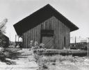
| Date: | 1961 |
|---|---|
| Description: | The Chicago and Northwestern railroad station. |

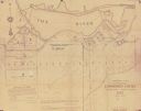
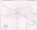
| Date: | |
|---|---|
| Description: | Plat map of the east central part of the city. |
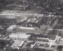
| Date: | 1961 |
|---|---|
| Description: | Aerial view of the Miller Electic Manufacturing Co. and surrounding area. |

| Date: | |
|---|---|
| Description: | View over a train stopped at a grain elevator in the foreground. The Hotel Ristau is across a street on the left, and a church building is in the distance ... |
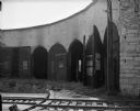
| Date: | 09 16 1961 |
|---|---|
| Description: | An interior view of an abandoned Chicago and North Western Railroad roundhouse. |

| Date: | |
|---|---|
| Description: | Elevated view of factories and railway line along the Fox River. Caption reads: "View of Water Power from Wests Park, Appleton, Wis." |

| Date: | 1898 |
|---|---|
| Description: | This 1898 map of Outagamie County, Wisconsin, shows the township and range grid, towns, sections, cities and villages, the Oneida Reservation, landownershi... |

| Date: | 1903 |
|---|---|
| Description: | This 1903 map of Outagamie County, Wisconsin, shows the township and range grid, towns, sections, cities and villages, landownership and acreages, rural ma... |

| Date: | 1922 |
|---|---|
| Description: | This map of Outagamie County, Wisconsin, from the first half of the 20th century, shows the township and range grid, towns, sections, cities and villages, ... |
| Date: | 1927 |
|---|---|
| Description: | Shows landowner's lots, roads, railroads, and Fox River. Also includes certificate of survey text. Includes significant manuscript annotations depicting th... |

| Date: | 1873 |
|---|---|
| Description: | Map shows townships and sections, landownership and acreages, state and county lands, churches, schools, cemeteries, roads, and railroads. There is an inse... |

| Date: | 1952 |
|---|---|
| Description: | Map shows roads, highways, railroads, parks, city buildings, schools, cemeteries, city limits, and the Fox River. The map is indexed by street name, street... |

| Date: | 1916 |
|---|---|
| Description: | Map shows roads, railroads, the Fox River, parks, and cemeteries. Wards are numbered and the edges of the map feature coordinates. The top left of the map ... |

| Date: | 01 1940 |
|---|---|
| Description: | Map shows roads, railroads, the Fox River, parks, schools, and cemeteries and is indexed by street name in the margins. The bottom of the map show the Winn... |

| Date: | 1957 |
|---|---|
| Description: | Map is indexed by street name in the margins. The map shows roads, highways, railroads, parks, city buildings, schools, cemeteries, city limits, and the Fo... |

| Date: | 1960 |
|---|---|
| Description: | This map shows a plat of the city, wards, lots, local streets, roads, railroads, buildings, parks, and part of Fox River. The map includes tables for plat ... |
| Date: | 1904 |
|---|---|
| Description: | This map shows land parcels, street names, and school locations, and potential land additions to the town. The Wisconsin Central Railroad is labeled. |
If you didn't find the material you searched for, our Library Reference Staff can help.
Call our reference desk at 608-264-6535 or email us at: