 Filter: Categories of Wisconsin Historical Images
Filter: County of Outagamie
Filter: Subject of human settlements
Filter: Categories of Wisconsin Historical Images
Filter: County of Outagamie
Filter: Subject of human settlements
| Date: | |
|---|---|
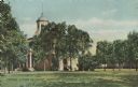
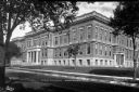
| Description: | View across lawn toward the campus. Caption reads: "Campus & Main Building, Lawrence University, Appleton, Wis." |
| Date: | |
|---|---|
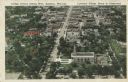
| Description: | Aerial view of College Avenue looking west. Several campus buildings at Lawrence College are in the foreground. Caption reads: "College Avenue looking West... |

| Date: | 08 03 1905 |
|---|---|
| Description: | Photographic postcard of a scene of the Fox River near Lawrence University. The Main Building at Lawrence University can be seen in the background on the r... |

| Date: | 02 1989 |
|---|---|
| Description: | Outdoor gathering of men, women and children cooking cranberries in a large kettle, perhaps at a winter festival. |
| Date: | |
|---|---|
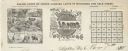
| Description: | Letterhead of Baldwin & Killen Lands and W.H. Killen & Company, dealers of farm, lumber, and mineral lands, from Appleton, Wisconsin, with an image on the ... |

| Date: | |
|---|---|
| Description: | Billhead of Star Brewery of Appleton, Wisconsin, with an elevated three-quarter view of the brewery and surrounding streets and buildings. On the right sid... |
| Date: | |
|---|---|
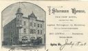
| Description: | Letterhead of Sherman House of Appleton, Wisconsin, with a three-quarter view of the hotel and people standing on the corner, walking on the sidewalk, or d... |
| Date: | |
|---|---|
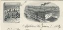
| Description: | Letterhead of the Atlas Paper Company of Appleton, Wisconsin, a paper company established in 1878. On the left is a scroll embellished with a spray of flow... |
| Date: | |
|---|---|
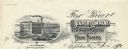
| Description: | Letterhead of the Fox River Paper Company of Appleton, Wisconsin, with a three-quarter view of the company building and a hanging roll of paper that incorp... |
| Date: | 1955 |
|---|---|
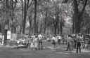
| Description: | Prospective buyers examine artwork at an art fair at City Park. |

| Date: | 1898 |
|---|---|
| Description: | This 1898 map of Outagamie County, Wisconsin, shows the township and range grid, towns, sections, cities and villages, the Oneida Reservation, landownershi... |

| Date: | 1903 |
|---|---|
| Description: | This 1903 map of Outagamie County, Wisconsin, shows the township and range grid, towns, sections, cities and villages, landownership and acreages, rural ma... |

| Date: | |
|---|---|
| Description: | This 1907 map of Outagamie County, Wisconsin, shows the township and range grid, towns, sections, cities and villages, railroads, wagon roads, churches, sc... |

| Date: | 1922 |
|---|---|
| Description: | This map of Outagamie County, Wisconsin, from the first half of the 20th century, shows the township and range grid, towns, sections, cities and villages, ... |
| Date: | |
|---|---|
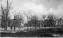
| Description: | Exterior view of Appleton High School. Caption reads: "High School - Appleton, Wis." |
| Date: | |
|---|---|
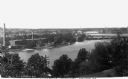
| Description: | Elevated view of hydroelectric plants on the Fox River. Caption reads: "Water Power - Looking West. Appleton, Wis." |
| Date: | |
|---|---|
| Description: | View of Lawrence University campus. Two men stand on the sidewalk in the foreground. Caption reads: "Lawrence University Campus, Appleton, Wis." |
| Date: | 1927 |
|---|---|
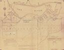
| Description: | Shows landowner's lots, roads, railroads, and Fox River. Also includes certificate of survey text. Includes significant manuscript annotations depicting th... |
| Date: | |
|---|---|
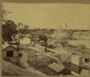
| Description: | Elevated view of a lock at Appleton, with views of mills and other structures in the background. |

| Date: | 1873 |
|---|---|
| Description: | Map shows townships and sections, landownership and acreages, state and county lands, churches, schools, cemeteries, roads, and railroads. There is an inse... |
If you didn't find the material you searched for, our Library Reference Staff can help.
Call our reference desk at 608-264-6535 or email us at: