 Filter: Categories of Wisconsin Historical Images
Filter: County of Outagamie
Filter: Subject of human settlements
Filter: Year of 1900-1999
Filter: Year of 1960-1969
Filter: Categories of Wisconsin Historical Images
Filter: County of Outagamie
Filter: Subject of human settlements
Filter: Year of 1900-1999
Filter: Year of 1960-1969
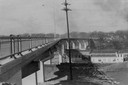
| Date: | 1960 |
|---|---|
| Description: | View of a bridge reaching across the Fox River. |
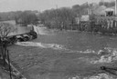
| Date: | 1960 |
|---|---|
| Description: | Elevated view looking down at the Fox River. On the left is a dam, and on the opposite shoreline is a factory. |
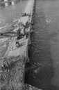
| Date: | 1960 |
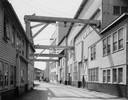
|---|---|
| Description: | View looking down at people working on John Street Bridge during the razing. There is a crane on the bridge. |
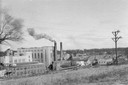
| Date: | 1960 |
|---|---|
| Description: | A paper and pulp mill in Appleton. The Interlake Pulp & Paper Mill of Appleton was absorbed by Consolidated Paper, Inc. in 1916, becoming their Interlake D... |
| Date: | 1962 |
|---|---|
| Description: | Valley Iron Works Corporation buildings with alley way between them. |
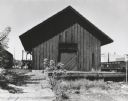
| Date: | 1961 |
|---|---|
| Description: | The Chicago and Northwestern railroad station. |
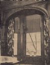
| Date: | 1960 |
|---|---|
| Description: | 625 W. Prospect Avenue. Dining room window overlooking the Fox River. Excerpt from the Appleton Post-Crescent, May 11, 1960. Home built by Henry J.... |

| Date: | 1960 |
|---|---|
| Description: | 625 W. Prospect Avenue, built in 1880 by H.J. Rogers. |
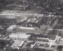
| Date: | 1961 |
|---|---|
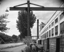
| Description: | Aerial view of the Miller Electic Manufacturing Co. and surrounding area. |

| Date: | 08 05 1962 |
|---|---|
| Description: | Mr. Ortel, a United States Government lock-keeper at Appleton lock number one on the Fox River canal. Mr. Ortel is opening the sluice gates to allow water ... |
| Date: | 08 05 1962 |
|---|---|
| Description: | Exterior view of Riverside Paper Corporation mill. On the left is a road along a river, and on the right are railroad tracks along the mill. A sign in the ... |

| Date: | 1960 |
|---|---|
| Description: | This map shows a plat of the city, wards, lots, local streets, roads, railroads, buildings, parks, and part of Fox River. The map includes tables for plat ... |

| Date: | 1968 |
|---|---|
| Description: | This map shows local streets, wards, buildings, parks, and part of the Fox River. The map is also indexed by street name. Ward borders and numbering and th... |

| Date: | 1960 |
|---|---|
| Description: | This map shows local streets, wards, public buildings, parks, and part of the Fox River. The land is shown in white and the water is shown in blue. The map... |

| Date: | 1960 |
|---|---|
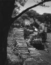
| Description: | Steam and smoke billow as a man is boiling maple syrup on the Harvey Blue farm. |
| Date: | 08 1963 |
|---|---|
| Description: | Elevated view of newspaper pulp wood stacked along the Fox River near the Combined Locks Paper Company. A crane is moving the logs, and workers are standin... |

| Date: | 10 1969 |
|---|---|
| Description: | A football player is leaping to avoid a tackle at Lawrence University. Two people are watching from the hillside in the background. |

| Date: | 1963 |
|---|---|
| Description: | Elevated view from East College Avenue bridge of motor boats exiting Lock #4 on the Upper Fox River. |
| Date: | 07 07 1961 |
|---|---|
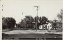
| Description: | Text on front reads: "Residential Street, Seymour, Wis." A street view of a neighborhood with homes, sidewalks and trees. |
If you didn't find the material you searched for, our Library Reference Staff can help.
Call our reference desk at 608-264-6535 or email us at:
