 Filter: Categories of Wisconsin Historical Images
Filter: County of Oneida
Filter: Subject of tourism
Filter: Categories of Wisconsin Historical Images
Filter: County of Oneida
Filter: Subject of tourism
| Date: | |
|---|---|
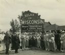
| Description: | Group of resort and hotel owners gathered in front of a Wisconsin tourism sign that reads: "Relax In Wisconsin." There is a building in the background. |

| Date: | 1915 |
|---|---|
| Description: | This 1915 map shows railroads, wagon roads, trails, creeks, rivers, lakes, and trout streams in Oneida and Lincoln counties within a 12 mile radius of Rhin... |

| Date: | 1900 |
|---|---|
| Description: | This map of Three Lakes shows forest fire lookout towers, picnic grounds, an airport, roads, and railroad. The map features text boxes on the Village of Th... |

| Date: | 1940 |
|---|---|
| Description: | This map shows lakes, roads, car trails, foot trails, railroads, resorts and camps, and fire towers. The map includes an inset location map and pictorial d... |
If you didn't find the material you searched for, our Library Reference Staff can help.
Call our reference desk at 608-264-6535 or email us at: