Filter: Categories of Wisconsin Historical Images
Filter: County of Oneida
Filter: Subject of industries
Filter: Categories of Wisconsin Historical Images
Filter: County of Oneida
Filter: Subject of industries
| Date: | 1900 |
|---|---|
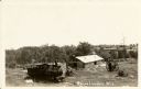
| Description: | Lake Shore Lumber Company of Oshkosh's mill waste lumber slab dump. Leander Choate, owner of mill, used this marsh for his waste lumber which was piled at ... |
| Date: | 1920 |
|---|---|
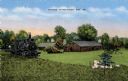
| Description: | Logging Museum in Rhinelander. Caption reads: "Museum, Rhinelander, Wis." |
| Date: | |
|---|---|
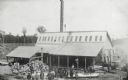
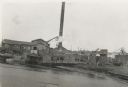
| Description: | Bissell Lumber Company. Workers are posing outdoors in front of a building. Cut trees can be seen in the background. A horse-drawn vehicle is on the right... |

| Date: | 2008 |
|---|---|
| Description: | According to the Minocqua Times, work on this yellow-glazed brick station, which stands at 329 Front Street, began in late 1931. |
| Date: | 1939 |
|---|---|
| Description: | A view from water of the Thunder Lake Lumber Co., one of the largest sawmills in Rhinelander. It was located on Lake Creek and operated until 1937. |
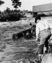
| Date: | 1895 |
|---|---|
| Description: | Crew of river drivers moving logs off of rocks below a dam probably on the Wisconsin River. |
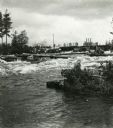
| Date: | 1890 |
|---|---|
| Description: | Log driving crew maneuvering logs through rapids below a dam, probably on the Wisconsin River. |

| Date: | |
|---|---|
| Description: | Letterhead of John A. Bosacki of Minocqua, Wisconsin, a cigar manufacturer, with an image of a cigar rolled in the "perfecto" shape. |

| Date: | |
|---|---|
| Description: | Letterhead of the Minocqua Lumber Company, with a footer of two houses near the water's edge with a forest in the background that extends along the left-ha... |
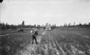
| Date: | 07 31 1895 |
|---|---|
| Description: | Chas B. Howe standing in his garden, holding cabbages, beets, onions, and turnips. The garden is located on the farm of John Hass, with 1.5 acres of onions... |

| Date: | 1900 |
|---|---|
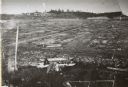
| Description: | This map shows logging roads, railroads with spur lines, trails, rapids, lumber camps, Indian villages, summer resort, lakes, rivers, and ponds. |

| Date: | 01 1936 |
|---|---|
| Description: | Two large smokestacks rise from the 1903 building of the Rhinelander Paper Company. Railroad tracks are crossing the left foreground diagonally; a second s... |

| Date: | 09 25 1937 |
|---|---|
| Description: | After a long day of fishing, the governors of three states are posing with ten muskies hanging from a birch log wired to two trees. Known as the "Battle of... |
If you didn't find the material you searched for, our Library Reference Staff can help.
Call our reference desk at 608-264-6535 or email us at: