 Filter: Categories of Wisconsin Historical Images
Filter: County of Monroe
Filter: Year of 1900-1999
Filter: Categories of Wisconsin Historical Images
Filter: County of Monroe
Filter: Year of 1900-1999
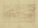
| Date: | 1931 |
|---|---|
| Description: | Top of the map reads: "SPECIAL MILITARY MAP 2626:2757:/27:2080:" and "Advance sheet, subject to correction." Bottom right of the map reads: "South Range gu... |

| Date: | 04 01 1959 |
|---|---|
| Description: | Indoor portrait of Margaret Frederick, Cashton, who has a large number of living descendants: 10 children, 86 grandchildren and 42 great-grandchildren. |
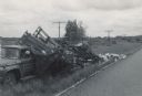
| Date: | 06 07 1966 |
|---|---|
| Description: | View from road of a truck pulled off to the side of the road. The back of the truck is collapsed, containing beehives spilling onto the ground. "E.R. Raley... |

| Date: | 1909 |
|---|---|
| Description: | This is one of a set of two topographical maps showing land use, roads, railroads, bridges, and buildings with ownership in parts of LaFayette, Greenfield,... |
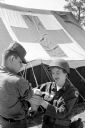
| Date: | 06 15 1961 |
|---|---|
| Description: | Pfc. Richard Sroda, a public information specialist with the 32nd Division, was the photographer and Sp4 David Gordon, public information specialist for th... |

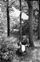
| Date: | 06 15 1961 |
|---|---|
| Description: | Pfc. Richard Sroda, a public information specialist with the 32nd Division, was the photographer and Sp4 David Gordon, public information specialist for th... |

| Date: | 06 16 1961 |
|---|---|
| Description: | Pfc. Richard Sroda, a public information specialist with the 32nd Division, was the photographer and Sp4 David Gordon, public information specialist for th... |

| Date: | 06 15 1961 |
|---|---|
| Description: | Pfc. Richard Sroda, a public information specialist with the 32nd Division, was the photographer and Sp4 David Gordon, public information specialist for th... |
| Date: | 06 15 1961 |
|---|---|
| Description: | Pfc. Richard Sroda, a public information specialist with the 32nd Division, was the photographer and Sp4 David Gordon, public information specialist for th... |

| Date: | 1903 |
|---|---|
| Description: | This map shows townships and sections, landownership and acreages, roads, railroads, and selected rural buildings. Townships and sections appear in yellow,... |

| Date: | 1920 |
|---|---|
| Description: | Four Native American men posing while clearing land for farming. One man is standing atop a stump which has been pulled from the ground. Another man is hol... |

| Date: | 1909 |
|---|---|
| Description: | This the second of a set of two topographical maps showing land use, roads, railroads, bridges, and buildings with ownership in parts of LaFayette, Greenfi... |

| Date: | 05 26 1947 |
|---|---|
| Description: | View across road and fields towards three wooded hill peaks. A roadside fence is in the foreground. Caption reads: "D.A. 36-268 — Three peaks on Hy.71 betw... |

| Date: | 1935 |
|---|---|
| Description: | A group of nine children, two girls and seven boys, sitting on the steps of the Indian School at Tomah. Two boys on the left are holding balls. All of the ... |
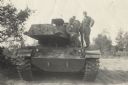
| Date: | 1961 |
|---|---|
| Description: | Lewis Arms (sitting in front on the left) and two other soldiers posing on a tank at Fort McCoy. |
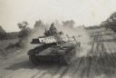
| Date: | 1961 |
|---|---|
| Description: | Several soldiers (possibly including Lewis Arms) riding along a tank trail in a tank at Fort McCoy. |
| Date: | 1911 |
|---|---|
| Description: | Elevated view across fields towards a small town. Caption reads: "General View of Leon, Wis." |
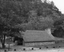
| Date: | 1938 |
|---|---|
| Description: | The picnic shelter at the east picnic area in Mill Bluff State Park is sitting at the base of a large rock outcropping. The shelter has low stone walls and... |
| Date: | 07 1949 |
|---|---|
| Description: | Elevated view of the Rifle Range at Camp McCoy during National Guard encampment of the 32nd Infantry Division. The soldiers are lined up in pairs on the le... |

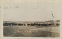
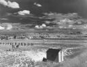
| Date: | 1910 |
|---|---|
| Description: | Slightly elevated view of a town, looking down from a hill across a field, with railroad tracks curving from the right foreground to the left towards the t... |
If you didn't find the material you searched for, our Library Reference Staff can help.
Call our reference desk at 608-264-6535 or email us at: