Filter: Categories of Wisconsin Historical Images
Filter: County of Monroe
Filter: Year of 1800-1899
Filter: Subject of land
Filter: Categories of Wisconsin Historical Images
Filter: County of Monroe
Filter: Year of 1800-1899
Filter: Subject of land
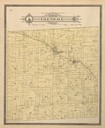
| Date: | 1897 |
|---|---|
| Description: | Plat Map of Glendale Township in Monroe County. |
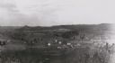
| Date: | 1880 |
|---|---|
| Description: | Elevated view from hill towards farm fields and houses. Tree-covered hills are in the distance. |
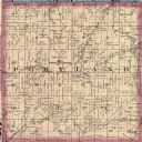
| Date: | 1878 |
|---|---|
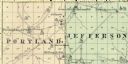
| Description: | A map of Portland and Jefferson in Monroe County. |

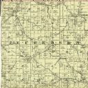
| Date: | 1877 |
|---|---|
| Description: | A map of Monroe County, Wisconsin that shows the townships and landownership and acreage wagon roads, railroads, streams, schools, and houses. Also include... |

| Date: | 1858 |
|---|---|
| Description: | Map shows township borders, marshes, pine timber, roads, railroads, and mills. The townships are are shown in blue/green, pink, and yellow. The map include... |
If you didn't find the material you searched for, our Library Reference Staff can help.
Call our reference desk at 608-264-6535 or email us at: