Filter: Categories of Wisconsin Historical Images
Filter: County of Monroe
Filter: Subject of bridges
Filter: Categories of Wisconsin Historical Images
Filter: County of Monroe
Filter: Subject of bridges

| Date: | 05 31 1965 |
|---|---|
| Description: | Elevated view of Evangelical United Brethren church in the vicinity of Highway T. |
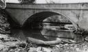
| Date: | 06 02 1943 |
|---|---|
| Description: | View from shoreline of bridge and stream. |

| Date: | 06 02 1943 |
|---|---|
| Description: | Looking west down road towards the bridge. The roadway is damaged in two spots, leaving large gaps. The walls of the bridge are still intact. Traffic barri... |
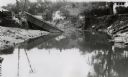
| Date: | 06 02 1943 |
|---|---|
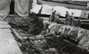
| Description: | View from water of bridge collapsed into the river, with the metal supports half submerged and the brick base crumbling. Dwellings can be seen along the hi... |
| Date: | 06 02 1943 |
|---|---|
| Description: | Looking south down street, with storefronts on either side. The street and bridge are undergoing reconstruction. Military vehicles are in the background. |
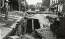
| Date: | 06 02 1943 |
|---|---|
| Description: | Looking Northwest. Workers are standing on the right next to the exposed drainage pipes in the damaged bridge. Sheets and quilts are covering the entranc... |
| Date: | 06 02 1943 |
|---|---|
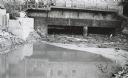
| Description: | Behind the drugstore, looking downstream. The water under the bridge is full of construction debris. |
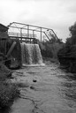
| Date: | 1931 |
|---|---|
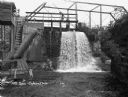
| Description: | Water pouring through a dam into a reservoir. Two workers are on top of a platform over the dam. |
| Date: | |
|---|---|
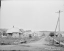
| Description: | View down Water Street which is lined with sidewalks and residential houses. In the foreground on both sides of the road are small wooden bridges along the... |

| Date: | 1909 |
|---|---|
| Description: | This is one of a set of two topographical maps showing land use, roads, railroads, bridges, and buildings with ownership in parts of LaFayette, Greenfield,... |

| Date: | 1909 |
|---|---|
| Description: | This the second of a set of two topographical maps showing land use, roads, railroads, bridges, and buildings with ownership in parts of LaFayette, Greenfi... |

| Date: | 06 28 1917 |
|---|---|
| Description: | Text on front reads: "Spring Bank, Near Tomah." Three women and a man stand on a wooden suspension bridge over a pond on Sparta Creek. One woman is holding... |
If you didn't find the material you searched for, our Library Reference Staff can help.
Call our reference desk at 608-264-6535 or email us at: