 Filter: Categories of Wisconsin Historical Images
Filter: County of Monroe
Filter: Creator Name of United States. Army. Corps of Engineers.
Filter: Categories of Wisconsin Historical Images
Filter: County of Monroe
Filter: Creator Name of United States. Army. Corps of Engineers.
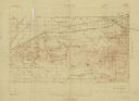
| Date: | 1931 |
|---|---|
| Description: | Top of the map reads: "SPECIAL MILITARY MAP 2626:2757:/27:2080:" and "Advance sheet, subject to correction." Bottom right of the map reads: "South Range gu... |

| Date: | 1909 |
|---|---|
| Description: | This is one of a set of two topographical maps showing land use, roads, railroads, bridges, and buildings with ownership in parts of LaFayette, Greenfield,... |

| Date: | 1909 |
|---|---|
| Description: | This the second of a set of two topographical maps showing land use, roads, railroads, bridges, and buildings with ownership in parts of LaFayette, Greenfi... |
If you didn't find the material you searched for, our Library Reference Staff can help.
Call our reference desk at 608-264-6535 or email us at: