 Filter: Categories of Wisconsin Historical Images
Filter: County of Milwaukee
Filter: Year of 1800-1899
Filter: Year of 1840-1849
Filter: Categories of Wisconsin Historical Images
Filter: County of Milwaukee
Filter: Year of 1800-1899
Filter: Year of 1840-1849
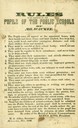
| Date: | 1846 |
|---|---|
| Description: | "Rules to be observed by the pupils of public schools of Milwaukee." |
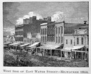
| Date: | 1844 |
|---|---|
| Description: | Illustration of the west side of East Water Street. |
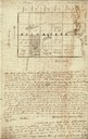
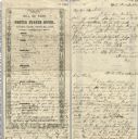
| Date: | 01 12 1844 |
|---|---|
| Description: | Letter from Thomas Steel, Waukesha County physician and farmer, to his father, James Steel, in London, England. It includes a hand-drawn map of Milwaukee C... |
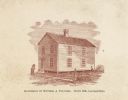
| Date: | 1840 |
|---|---|
| Description: | Home of William Augustus Prentiss, built in 1836 and burned in 1845. Small two-story house. Four people are standing around the house. |

| Date: | 1847 |
|---|---|
| Description: | Drawing of a Native American man looking into the Milwaukee settlement. |
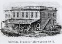
| Date: | 1843 |
|---|---|
| Description: | Exterior of two-story wood building at the corner of Wisconsin and Water Streets. The first floor consists of businesses run by Dewey, Highby & Wardner, a... |

| Date: | 05 1846 |
|---|---|
| Description: | Hand-colored map of southeastern Wisconsin showing the counties of Dodge, Jefferson, Rock, Walworth, Racine (including modern-day Kenosha County), Waukesha... |

| Date: | 1844 |
|---|---|
| Description: | An ink on paper, hand-drawn map of Milwaukee County that shows the sectioning of townships, the boundary of the canal grant, roads, streams, lakes, includi... |

| Date: | 1849 |
|---|---|
| Description: | A hand-drawn map of showing the two proposed routes from the Milwaukee River to the Moody’s Lime Quarry at Milwaukee, Wisconsin. The map includes the route... |

| Date: | 1848 |
|---|---|
| Description: | Pen-and-ink on paper. The title of the map is inscribed on the back. The map shows buildings, roads, marshes, wild rice, piles and docks, deep water, and o... |

| Date: | 1840 |
|---|---|
| Description: | Pen-and-ink on paper. Map shows 1840’s homes with owner names, a Native American cemetery, and other points of interest. Relief shown by hachures. Oriented... |
| Date: | 09 21 1846 |
|---|---|
| Description: | Bill of fare for the United States Hotel, with decorative border ornaments running along the sides, top, and bottom of the menu, and general printed catego... |
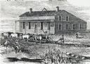
| Date: | 1840 |
|---|---|
| Description: | Sod-breaker and five yoke of oxen plowing in front of the “Old Cottage Inn.” In the foreground a boat is on the shoreline. |

| Date: | 1840 |
|---|---|
| Description: | This manuscript map is ink, pencil, and watercolor on paper and shows landownership. An approximate date can be established by the names written on the pla... |

| Date: | 1846 |
|---|---|
| Description: | This map shows lot and block numbers, roads, railroads, and some landowners’ names and includes the manuscript annotations: "From the Lapham collection" --... |

| Date: | 1845 |
|---|---|
| Description: | This map shows lot and block numbers, local streets, railroads, some landowners’ names, Milwaukee River, Menomonee River, and part of Lake Michigan. The ma... |

| Date: | 1846 |
|---|---|
| Description: | This map shows lot and block numbers, local streets, railroads, some landowners’ names, Milwaukee River, Menomonee River, and part of Lake Michigan. The ma... |

| Date: | 1847 |
|---|---|
| Description: | This map shows lot and block numbers, roads, railroads, and some landowners’ names. Lake Michigan, the Milwaukee River, and the Menomonee River are labeled... |

| Date: | 1848 |
|---|---|
| Description: | This map shows lot and block numbers, roads, railroads, and some landowners’ names. Lake Michigan, the Milwaukee River, and the Menomonee River are labeled... |

| Date: | 1849 |
|---|---|
| Description: | This map shows lot and block numbers, wards, local streets, railroads, some landowners’ names, Milwaukee River, Menomonee River, and part of Lake Michigan.... |
If you didn't find the material you searched for, our Library Reference Staff can help.
Call our reference desk at 608-264-6535 or email us at: