 Filter: Categories of Wisconsin Historical Images
Filter: County of Milwaukee
Filter: Year of 1800-1899
Filter: Year of 1840-1849
Filter: Year of 1846
Filter: Categories of Wisconsin Historical Images
Filter: County of Milwaukee
Filter: Year of 1800-1899
Filter: Year of 1840-1849
Filter: Year of 1846
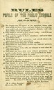
| Date: | 1846 |
|---|---|
| Description: | "Rules to be observed by the pupils of public schools of Milwaukee." |

| Date: | 05 1846 |
|---|---|
| Description: | Hand-colored map of southeastern Wisconsin showing the counties of Dodge, Jefferson, Rock, Walworth, Racine (including modern-day Kenosha County), Waukesha... |
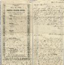
| Date: | 09 21 1846 |
|---|---|
| Description: | Bill of fare for the United States Hotel, with decorative border ornaments running along the sides, top, and bottom of the menu, and general printed catego... |

| Date: | 1846 |
|---|---|
| Description: | This map shows lot and block numbers, roads, railroads, and some landowners’ names and includes the manuscript annotations: "From the Lapham collection" --... |

| Date: | 1846 |
|---|---|
| Description: | This map shows lot and block numbers, local streets, railroads, some landowners’ names, Milwaukee River, Menomonee River, and part of Lake Michigan. The ma... |
If you didn't find the material you searched for, our Library Reference Staff can help.
Call our reference desk at 608-264-6535 or email us at: