 Filter: Categories of Wisconsin Historical Images
Filter: County of Milwaukee
Filter: Year of 1800-1899
Filter: Year of 1830-1839
Filter: Categories of Wisconsin Historical Images
Filter: County of Milwaukee
Filter: Year of 1800-1899
Filter: Year of 1830-1839
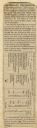
| Date: | 07 22 1837 |
|---|---|
| Description: | Table printed in Milwaukee Advertiser indicating the time of flowering of several wild plants at Milwaukee and near the head of the Pishtaka River. |
| Date: | 1836 |
|---|---|
| Description: | This map is oriented with the north to the lower right. Lake Michigan, the Menomonie River, and the Milwaukee River are labeled. Depths are shown by isolin... |

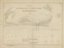
| Date: | 1837 |
|---|---|
| Description: | This map shows the proposed Rock River Canal, between Milwaukee County thru the west line of what is now Waukesha County. Also shows townships, roads, hydr... |
If you didn't find the material you searched for, our Library Reference Staff can help.
Call our reference desk at 608-264-6535 or email us at: