 Filter: Categories of Wisconsin Historical Images
Filter: County of Menominee
Filter: Subject of menominee indians
Filter: Categories of Wisconsin Historical Images
Filter: County of Menominee
Filter: Subject of menominee indians

| Date: | 1970 |
|---|---|
| Description: | This map shows land owned by Menominee Enterprise Inc., land sold to Menominee shareholders, and land sold to non-Menominees. The map also includes water a... |
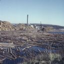
| Date: | 1957 |
|---|---|
| Description: | View from shoreline of logs floating in the water of Neopit Mill Pond. The sawmill is across the water, partially obscured by tall piles of logs. |
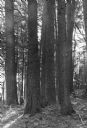
| Date: | 1940 |
|---|---|
| Description: | Lear Shewano is dwarfed by a grove of huge virgin white pine trees in the Menominee Indian Reservation. He is wearing a white hat and plaid shirt. |
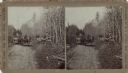
| Date: | |
|---|---|
| Description: | Stereograph of two Menomonee Indian family groups in horse-drawn wagons. One boy is standing next to a wagon and a man is standing on the right holding a g... |
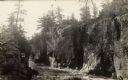
| Date: | |
|---|---|
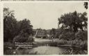
| Description: | The Dells of the Wolf River in the Menominee Indian Reservation. |
| Date: | |
|---|---|
| Description: | View over water towards a road leading to a bridge. A man is standing next to an automobile on the side of the road. |
| Date: | 1972 |
|---|---|
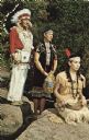
| Description: | Text on back reads: "Menominee Indians . . . Indian family chief, mother, daughter, at Wolf River Falls, Neopit, Wis." |
| Date: | 07 08 1972 |
|---|---|
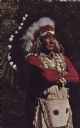
| Description: | Text on reverse reads: "Menominee Chief in priceless full head dress of rare Eagle feathers. Neopit, Wis." A native American man stands with his arms cross... |
If you didn't find the material you searched for, our Library Reference Staff can help.
Call our reference desk at 608-264-6535 or email us at: