 Filter: Categories of Wisconsin Historical Images
Filter: County of Menominee
Filter: Subject of human settlements
Filter: Categories of Wisconsin Historical Images
Filter: County of Menominee
Filter: Subject of human settlements

| Date: | 1956 |
|---|---|
| Description: | This map shows reservation boundaries, U.S. township lines, highways, roads, rivers, and lakes. The lower left corner of the map includes a legend of "Conv... |

| Date: | 1970 |
|---|---|
| Description: | This map shows land owned by Menominee Enterprise Inc., land sold to Menominee shareholders, and land sold to non-Menominees. The map also includes water a... |

| Date: | |
|---|---|
| Description: | Photographic postcard view across field towards a row of apartment buildings. Caption reads: "At Keshena Falls on Highway #47, Wis." |
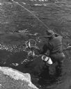
| Date: | 10 1962 |
|---|---|
| Description: | Elevated view of a fisherman netting his fish near the bridge at Keshena Falls. Caption on reverse reads: "This is an actual catch I just happened to be pr... |
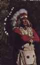
| Date: | 07 08 1972 |
|---|---|
| Description: | Text on reverse reads: "Menominee Chief in priceless full head dress of rare Eagle feathers. Neopit, Wis." A native American man stands with his arms cross... |
If you didn't find the material you searched for, our Library Reference Staff can help.
Call our reference desk at 608-264-6535 or email us at: