Filter: Categories of Wisconsin Historical Images
Filter: County of Menominee
Filter: Subject of human settlements
Filter: Creator Name of Unknown
Filter: Categories of Wisconsin Historical Images
Filter: County of Menominee
Filter: Subject of human settlements
Filter: Creator Name of Unknown
| Date: | 1929 |
|---|---|
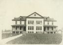
| Description: | The Government Indian School in Keshena. |
| Date: | 1929 |
|---|---|
| Description: | The U.S. Department of the Interior, Keshena Indian School. |
| Date: | 1923 |
|---|---|
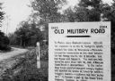
| Description: | Old Military Road sign. Sign reads: "1864 — 1924 Old Military Road — In March — 1863 — Abraham Lincoln affixed his signature to an act of Congress which en... |
| Date: | 1912 |
|---|---|
| Description: | View across street towards the Stout Manual Training School on the left, and the high school on the right. Captions read: "Stout Manual Training School," "... |
| Date: | 1890 |
|---|---|
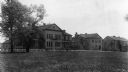
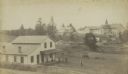
| Description: | Farmer's house with rear of the government Contract School on the Menominee reservation in the distance. The Keshena Creek flows between the farmhouse and ... |
| Date: | 1902 |
|---|---|
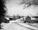
| Description: | Elevated winter scene of snow-covered road through Keshena, Wisconsin. There are horse-drawn vehicles and pedestrians, and a church is in the background. |
| Date: | |
|---|---|
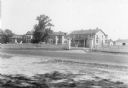
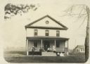
| Description: | Exterior of Keshena Boardinghouse with a group of men, women and children positioned on the front porch. |
| Date: | |
|---|---|
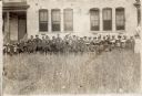
| Description: | Group portrait of Menominee Indian students and teachers in front of the Keshena Schoolhouse. |
| Date: | |
|---|---|
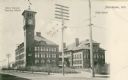
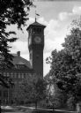
| Description: | A building with an attached clock tower stands on the campus of the Stout Institute (now the University of Wisconsin-Stout). Trees and shrubbery stand on ... |

| Date: | 1947 |
|---|---|
| Description: | Shows lot and block numbers, 28 points of interest in the upper left that correspond to numbers on the map, and landownership with acreages. "Erickson Brot... |

| Date: | 1970 |
|---|---|
| Description: | This map shows land owned by Menominee Enterprise Inc., land sold to Menominee shareholders, and land sold to non-Menominees. The map also includes water a... |

| Date: | |
|---|---|
| Description: | Photographic postcard view across field towards a row of apartment buildings. Caption reads: "At Keshena Falls on Highway #47, Wis." |
If you didn't find the material you searched for, our Library Reference Staff can help.
Call our reference desk at 608-264-6535 or email us at: