 Filter: Categories of Wisconsin Historical Images
Filter: County of Menominee
Filter: Creator Name of Unknown
Filter: Categories of Wisconsin Historical Images
Filter: County of Menominee
Filter: Creator Name of Unknown

| Date: | 1947 |
|---|---|
| Description: | Shows lot and block numbers, 28 points of interest in the upper left that correspond to numbers on the map, and landownership with acreages. "Erickson Brot... |

| Date: | |
|---|---|
| Description: | Photographic postcard of Smoky Falls, now called Big Smokey Falls and found within the Menominee Nation. A boy is standing on the left near the falls. |

| Date: | 1970 |
|---|---|
| Description: | This map shows land owned by Menominee Enterprise Inc., land sold to Menominee shareholders, and land sold to non-Menominees. The map also includes water a... |

| Date: | 1930 |
|---|---|
| Description: | View of a sign identifying the Spirit Rock, which is a large boulder surrounded by sturdy protective posts. There are tree stumps in the foreground and a w... |
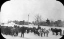
| Date: | 1925 |
|---|---|
| Description: | Slightly elevated view of a group of men gathered around four teams of horses hitched to sleighs in a snow covered lot. There is a dog at the center of the... |

| Date: | |
|---|---|
| Description: | Photographic postcard view across field towards a row of apartment buildings. Caption reads: "At Keshena Falls on Highway #47, Wis." |
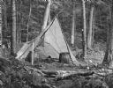
| Date: | 1940 |
|---|---|
| Description: | Two large woven baskets with shoulder straps are sitting on the ground in front of an open tepee in a forest clearing. There are two tin cups on the ground... |
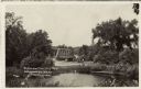
| Date: | |
|---|---|
| Description: | View over water towards a road leading to a bridge. A man is standing next to an automobile on the side of the road. |
If you didn't find the material you searched for, our Library Reference Staff can help.
Call our reference desk at 608-264-6535 or email us at: