 Filter: Categories of Wisconsin Historical Images
Filter: County of Marinette
Filter: Year of 1800-1899
Filter: Categories of Wisconsin Historical Images
Filter: County of Marinette
Filter: Year of 1800-1899

| Date: | 1896 |
|---|---|
| Description: | A map of Marinette County, Wisconsin that shows the sectioning of townships and other plots, towns, cities and villages, lakes and streams, railroads, and... |

| Date: | 1851 |
|---|---|
| Description: | This manuscript map of the southern portion of the Town of Porterfield, Marinette County, Wisconsin, shows sections and land ownership. The Menominee River... |

| Date: | 1887 |
|---|---|
| Description: | This manuscript map of the southern portion of the Town of Porterfield, Marinette County, Wisconsin, shows sections and land ownership. The Menominee River... |
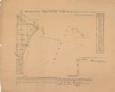
| Date: | 1856 |
|---|---|
| Description: | Shows sections and acreages. Covers portions of the area now occupied by Marinette and the Town of Peshtigo, Marinette County. "Rec’d Sept. 24 with Sur. Ge... |
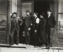
| Date: | 1897 |
|---|---|
| Description: | Group of railroad employees standing in the doorway of a store. |
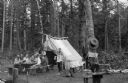
| Date: | 1890 |
|---|---|
| Description: | A group of men sharing a meal at a fishing camp near Thunder Lake. |
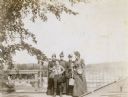
| Date: | 1892 |
|---|---|
| Description: | Standing with the Menominee River in the background, Mary Mathilda Axtell Rumsey and her family posing for a picture. Names from left to right: Mary Mathil... |
If you didn't find the material you searched for, our Library Reference Staff can help.
Call our reference desk at 608-264-6535 or email us at: