Filter: Categories of Wisconsin Historical Images
Filter: County of Marinette
Filter: Year of 1800-1899
Filter: Subject of water
Filter: Subject of human settlements
Filter: Categories of Wisconsin Historical Images
Filter: County of Marinette
Filter: Year of 1800-1899
Filter: Subject of water
Filter: Subject of human settlements

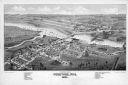
| Date: | 09 1871 |
|---|---|
| Description: | Bird's-eye view of Peshtigo, before it was destroyed by fire on the night of October 8, 1871. |
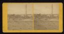
| Date: | 1871 |
|---|---|
| Description: | Ruins of building showing smokestack still standing after the Peshtigo fire. A group of men are standing on the left. |

| Date: | 1881 |
|---|---|
| Description: | Bird's-eye map of Marinette, with insets. |

| Date: | 1871 |
|---|---|
| Description: | Drawing of the Peshtigo Fire, showing people seeking refuge in the Peshtigo River. |
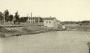
| Date: | 1887 |
|---|---|
| Description: | View of the boom company office and the site of the old trading post. |

| Date: | 1896 |
|---|---|
| Description: | A map of Marinette County, Wisconsin that shows the sectioning of townships and other plots, towns, cities and villages, lakes and streams, railroads, and... |

| Date: | 1851 |
|---|---|
| Description: | This manuscript map of the southern portion of the Town of Porterfield, Marinette County, Wisconsin, shows sections and land ownership. The Menominee River... |

| Date: | 1887 |
|---|---|
| Description: | This manuscript map of the southern portion of the Town of Porterfield, Marinette County, Wisconsin, shows sections and land ownership. The Menominee River... |
If you didn't find the material you searched for, our Library Reference Staff can help.
Call our reference desk at 608-264-6535 or email us at: