 Filter: Categories of Wisconsin Historical Images
Filter: County of Marinette
Filter: Subject of roads
Filter: Categories of Wisconsin Historical Images
Filter: County of Marinette
Filter: Subject of roads
| Date: | |
|---|---|
| Description: | Wisconsin Land Economic Inventory mapping crew starting out in the snow for instruction. |

| Date: | 1917 |
|---|---|
| Description: | View down unpaved road toward the front of the asylum. Caption reads: "Marinette County Insane Asylum, Marinette, Wis." |
| Date: | 1910 |
|---|---|
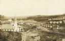
| Description: | An elevated view of town. A church is on the left, houses are in rows on the right. Caption reads: "Made-For-Club-House — Niagara-Wis.—". |
| Date: | 1923 |
|---|---|
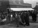
| Description: | A street gathering of people interested in using war-salvaged explosives for a land clearance program. |

| Date: | 2008 |
|---|---|
| Description: | Built in about 1933, this appealingly picturesque service station, located at 1305 Pierce Avenue, was designed to blend into the neighborhood. |

| Date: | |
|---|---|
| Description: | Exterior view from road of the Stephenson Public Library. Above the main entrance it reads: "Stephenson Public Library." The library is a cut stone buildin... |

| Date: | |
|---|---|
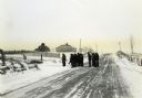
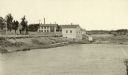
| Description: | Colorized view of a road along a river. Caption reads: "The River Road, Marinette, Wis." |
| Date: | |
|---|---|
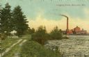
| Description: | Colorized view of a river full of logs, and a smokestack and factory in the distance. On the left is a dirt road and trees. Caption reads: "Logging Scene, ... |
| Date: | 1887 |
|---|---|
| Description: | View of the boom company office and the site of the old trading post. |

| Date: | 1896 |
|---|---|
| Description: | A map of Marinette County, Wisconsin that shows the sectioning of townships and other plots, towns, cities and villages, lakes and streams, railroads, and... |

| Date: | 1923 |
|---|---|
| Description: | A hand-colored map of Marinette County, Wisconsin that shows, townships, towns and plot sections, lakes and streams, cities and villages, and rail lines an... |

| Date: | 1941 |
|---|---|
| Description: | A tourist map of Marinette County, Wisconsin that includes indexes of the lakes and rivers in the county which also identify the fish present, a list of ra... |

| Date: | 1900 |
|---|---|
| Description: | A map of Marinette County, Wisconsin shows the township and range system, sections, towns, cities and villages, streams and lakes, railroads, roads, school... |

| Date: | 1920 |
|---|---|
| Description: | Map shows townships and sections, landownership and acreages, roads, and railroads in southwest portion of Marinette County. Sections of the map are in ye... |
| Date: | 1925 |
|---|---|
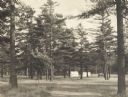
| Description: | Stand of pine trees and pitched tents, with automobiles, in the Marinette Tourist Camp. |

| Date: | 1920 |
|---|---|
| Description: | A winter scene showing two men standing behind the blade, on either side of the cab, of a Caterpillar Wausau-Plow Snow V-Plow. They are removing snow from ... |

| Date: | 1912 |
|---|---|
| Description: | This blueprint manuscript map shows selected buildings, roads, and the Peshtigo River. |

| Date: | 2000 |
|---|---|
| Description: | This map shows Wisconsin Public Service Corporation property, special regulation areas, public boat landings, roads, parks, and other recreation areas. Ins... |

| Date: | 1905 |
|---|---|
| Description: | This photocopied map shows landownership, roads, railroads, rural mail routes, churches, school houses, cemeteries, and townships. The map includes adverti... |

| Date: | 1912 |
|---|---|
| Description: | Marinette County, Township 37 N., Range 20 E. |
If you didn't find the material you searched for, our Library Reference Staff can help.
Call our reference desk at 608-264-6535 or email us at: