 Filter: Categories of Wisconsin Historical Images
Filter: County of Marinette
Filter: Subject of islands
Filter: Categories of Wisconsin Historical Images
Filter: County of Marinette
Filter: Subject of islands

| Date: | 09 1871 |
|---|---|
| Description: | Bird's-eye view of Peshtigo, before it was destroyed by fire on the night of October 8, 1871. |

| Date: | 1881 |
|---|---|
| Description: | Bird's-eye map of Marinette, with insets. |
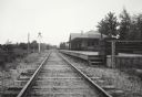
| Date: | |
|---|---|
| Description: | View down railroad tracks which pass the Miscauno Island depot. A railroad signal is on the left, and the platform for the depot is on the right. |

| Date: | 1920 |
|---|---|
| Description: | This map shows a small island in the Menominee River and includes a survey table and certification. |
If you didn't find the material you searched for, our Library Reference Staff can help.
Call our reference desk at 608-264-6535 or email us at: