| Date: | 1941 |
|---|---|
| Description: | A tourist map of Marinette County, Wisconsin that includes indexes of the lakes and rivers in the county which also identify the fish present, a list of ra... |

| Date: | 1887 |
|---|---|
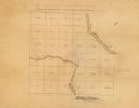
| Description: | This manuscript map of the southern portion of the Town of Porterfield, Marinette County, Wisconsin, shows sections and land ownership. The Menominee River... |

| Date: | |
|---|---|
| Description: | This 19th century manuscript map shows the southeastern portion of the Town of Stephenson in Marinette County, Wisconsin. Sections, lakes, and streams are ... |

| Date: | |
|---|---|
| Description: | This 19th century manuscript map shows the sections and land ownership in the northern portion of the Town of Grover and the southern part of the Town of L... |

| Date: | 1920 |
|---|---|
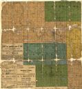
| Description: | Map shows townships and sections, landownership and acreages, roads, and railroads in southwest portion of Marinette County. Sections of the map are in ye... |
If you didn't find the material you searched for, our Library Reference Staff can help.
Call our reference desk at 608-264-6535 or email us at: