Filter: Categories of Wisconsin Historical Images
Filter: County of Marinette
Filter: Type of Map or Atlas
Filter: Categories of Wisconsin Historical Images
Filter: County of Marinette
Filter: Type of Map or Atlas

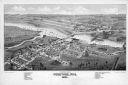
| Date: | 09 1871 |
|---|---|
| Description: | Bird's-eye view of Peshtigo, before it was destroyed by fire on the night of October 8, 1871. |

| Date: | 1881 |
|---|---|
| Description: | Bird's-eye map of Marinette, with insets. |

| Date: | 1896 |
|---|---|
| Description: | A map of Marinette County, Wisconsin that shows the sectioning of townships and other plots, towns, cities and villages, lakes and streams, railroads, and... |

| Date: | 1923 |
|---|---|
| Description: | A hand-colored map of Marinette County, Wisconsin that shows, townships, towns and plot sections, lakes and streams, cities and villages, and rail lines an... |

| Date: | 1941 |
|---|---|
| Description: | A tourist map of Marinette County, Wisconsin that includes indexes of the lakes and rivers in the county which also identify the fish present, a list of ra... |

| Date: | 1900 |
|---|---|
| Description: | A map of Marinette County, Wisconsin shows the township and range system, sections, towns, cities and villages, streams and lakes, railroads, roads, school... |

| Date: | 1851 |
|---|---|
| Description: | This manuscript map of the southern portion of the Town of Porterfield, Marinette County, Wisconsin, shows sections and land ownership. The Menominee River... |

| Date: | 1887 |
|---|---|
| Description: | This manuscript map of the southern portion of the Town of Porterfield, Marinette County, Wisconsin, shows sections and land ownership. The Menominee River... |

| Date: | |
|---|---|
| Description: | This 19th century manuscript map shows the southeastern portion of the Town of Stephenson in Marinette County, Wisconsin. Sections, lakes, and streams are ... |

| Date: | |
|---|---|
| Description: | This 19th century manuscript map shows the sections and land ownership in the northern portion of the Town of Grover and the southern part of the Town of L... |
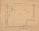
| Date: | 1856 |
|---|---|
| Description: | Shows sections and acreages. Covers portions of the area now occupied by Marinette and the Town of Peshtigo, Marinette County. "Rec’d Sept. 24 with Sur. Ge... |

| Date: | 1912 |
|---|---|
| Description: | Shows wards, sections, plat additions, selected buildings, churches, schools, and manufacturing companies. "We have revised this map from H. McCallum’s 189... |

| Date: | 1951 |
|---|---|
| Description: | Water depths shown by bathymetric tints and soundings. Relief shown by contours. "Depths in feet." "Aids to navigation corrected to May 4, 1951." On verso:... |

| Date: | 1920 |
|---|---|
| Description: | Map shows townships and sections, landownership and acreages, roads, and railroads in southwest portion of Marinette County. Sections of the map are in ye... |

| Date: | 1965 |
|---|---|
| Description: | This map shows streets, churches, schools, wards, railroads, parks and fields, cemeteries, Historical Museum, Yacht Basin & Marina, and Marinette General H... |

| Date: | 1912 |
|---|---|
| Description: | This blueprint manuscript map shows selected buildings, roads, and the Peshtigo River. |

| Date: | 1920 |
|---|---|
| Description: | This map shows a small island in the Menominee River and includes a survey table and certification. |

| Date: | 2000 |
|---|---|
| Description: | This map shows Wisconsin Public Service Corporation property, special regulation areas, public boat landings, roads, parks, and other recreation areas. Ins... |
If you didn't find the material you searched for, our Library Reference Staff can help.
Call our reference desk at 608-264-6535 or email us at: