 Filter: Categories of Wisconsin Historical Images
Filter: County of Marathon
Filter: Year of 1800-1899
Filter: Subject of human settlements
Filter: Categories of Wisconsin Historical Images
Filter: County of Marathon
Filter: Year of 1800-1899
Filter: Subject of human settlements

| Date: | 1891 |
|---|---|
| Description: | Bird's-eye map of Wausau, looking north with ninety-eight businesses, industries, churches, schools, and civic buildings identified in location key below i... |
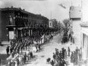
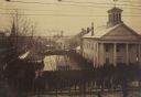
| Date: | 1892 |
|---|---|
| Description: | View of a large Columbus Day parade from Jackson and Third Streets. In the extreme right foreground is Conrad Althen's Store, and the Anderson and Larson S... |

| Date: | 1879 |
|---|---|
| Description: | This map is a bird's-eye view of Wausau, the County Seat of Marathon County. The map features an index of points of interest. |
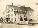
| Date: | 1875 |
|---|---|
| Description: | The Forest House, a hotel, restaurant and stage office. It was operated by Mr. and Mrs. Chas. A. Dingle and was located on the corner of Third and Forest S... |
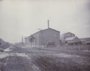
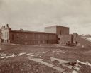
| Date: | 1880 |
|---|---|
| Description: | View of the Wausau Sand Paper Company, about 1903-1905, at Second and Thomas streets. |
| Date: | 1866 |
|---|---|
| Description: | Elevated view taken from the extreme end of Clark's Saw and Planing Mill. An old flour mill can be seen behind the bridge, and to the extreme right are thr... |
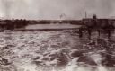
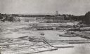
| Date: | 1890 |
|---|---|
| Description: | Elevated view looking up the Wisconsin River, with Wausau in the background. There are railroad cars on a bridge on the right. |
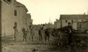
| Date: | 1864 |
|---|---|
| Description: | View looking north up Third Street near Market Square. There are five boys and a horse in the middle of the road. |

| Date: | 1880 |
|---|---|
| Description: | Clark's Saw and Planing Mill in the right foreground which is now the site of the electric plant. Behind Clark's is Plummers Mill where the Vocational Scho... |
| Date: | 1890 |
|---|---|
| Description: | Elevated view. The church in the left background is the Zion Lutheran Church. The white house behind the bandstand is Captain Leahy's home (father of Admir... |
| Date: | 1896 |
|---|---|
| Description: | View of the Cereal Mills Company building, with men and a horse-drawn buggy outside on of the buildings on the right. Another man is standing on the far le... |
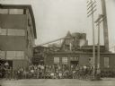
| Date: | 1884 |
|---|---|
| Description: | Men posed in front of and on top of a building at Plant One of the Curtis and Yale Co. Some of the men stand with bicycles. |

| Date: | 1870 |
|---|---|
| Description: | View toward front and right side of the Lincoln School, partially obscured by trees. The roof line features dormers and two towers. Caption reads: "Lincoln... |
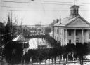
| Date: | 12 18 1890 |
|---|---|
| Description: | Elevated view looking down at homestead applicants waiting in line for 2-3 days in winter cold before a window in the Marathon County Court House, Dec. 18-... |
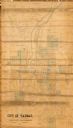
| Date: | 1892 |
|---|---|
| Description: | This map shows lot and block numbers and dimensions, some landownership, wards, railroads, streets, and mills. The map includes 5 plat additions that have ... |
| Date: | 1857 |
|---|---|
| Description: | This manuscript map is ink and watercolor on tracing cloth and shows bridges, lots, and streets. Some of the lots are in pink ink. The left of the map incl... |

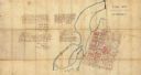
| Date: | 1899 |
|---|---|
| Description: | This map is ink on tracing cloth and shows lot and block numbers and dimensions, streets, the high school park, and survey monuments. The map is oriented ... |

| Date: | 1891 |
|---|---|
| Description: | View of the George Ruder Brewing Company. A group of men and a dog are posing near an entrance on the side of the brick building. A man is on a horse-drawn... |
If you didn't find the material you searched for, our Library Reference Staff can help.
Call our reference desk at 608-264-6535 or email us at: