Filter: Categories of Wisconsin Historical Images
Filter: County of Marathon
Filter: Subject of roads
Filter: Categories of Wisconsin Historical Images
Filter: County of Marathon
Filter: Subject of roads
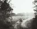
| Date: | 1906 |
|---|---|
| Description: | View down tree-lined country road near Wausau, taken by Dr. Joseph Smith, talented amateur photographer. It depicts women (probably members of his family) ... |

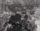
| Date: | 1891 |
|---|---|
| Description: | Bird's-eye map of Wausau, looking north with ninety-eight businesses, industries, churches, schools, and civic buildings identified in location key below i... |

| Date: | 05 02 1964 |
|---|---|
| Description: | Sitting on the school lawn, students draw Highway 51, Marathon Mill, Rib mountain and the Wisconsin River. |

| Date: | 1943 |
|---|---|
| Description: | This photocopy map shows inhabited farms, rivers, roads, and mills in the vicinity of Marathon City [and village of Edgar], including area between the Big ... |
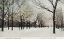
| Date: | 1920 |
|---|---|
| Description: | View down right side of a snow-covered street lined with trees toward the left side lined with houses. Caption reads: "Park Avenue, Berlin, Wis." |

| Date: | 04 30 1971 |
|---|---|
| Description: | The cheese factory owned by Bernard Herndel located on rural State Highway 13 in Marathon County. |
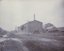
| Date: | 1880 |
|---|---|
| Description: | View of the Wausau Sand Paper Company, about 1903-1905, at Second and Thomas streets. |
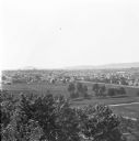
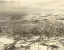
| Date: | 1912 |
|---|---|
| Description: | Elevated view of Wausau from the edge of town looking toward residences and businesses. Hills are in the far background. |
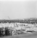
| Date: | 1912 |
|---|---|
| Description: | Winter view over fields of town with hills in the far background. |
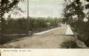
| Date: | 1905 |
|---|---|
| Description: | View down unpaved road towards Stroller's Bridge, with the city and a public building in the background. Caption reads: "Stroller's Bridge, Wausau, Wis." |
| Date: | 07 20 1988 |
|---|---|
| Description: | Panoramic view from the Big Sandy Creek Bridge, looking north on Marathon County Highway Q. |

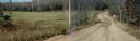
| Date: | 03 16 1984 |
|---|---|
| Description: | A wintertime panoramic view of the bridge on Rainbow Drive, a local road in the Town of Halsey, Marathon County, looking east. |
| Date: | 10 30 1987 |
|---|---|
| Description: | Panoramic view of 28th Avenue winding through the Town of Maine in Marathon County. |

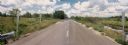
| Date: | 03 03 1988 |
|---|---|
| Description: | View from bridge over Wild Creek on Marathon County Highway M. The creek appears frozen, although in flood. Several farms can be seen in the distance. |
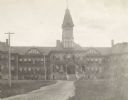
| Date: | 1900 |
|---|---|
| Description: | View of the Marathon County Asylum, with a dirt road leading to the main entrance. |
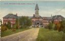
| Date: | 1905 |
|---|---|
| Description: | View looking down the dirt road framed by trees toward the Marathon County Asylum. Caption reads: "Marathon County Asylum, Wausau, Wis." |

| Date: | 1910 |
|---|---|
| Description: | View of the Falls Bridge and surrounding buildings. Caption reads: "Falls Bridge, Bet. East and West Sides, Wausau, Wis." |
If you didn't find the material you searched for, our Library Reference Staff can help.
Call our reference desk at 608-264-6535 or email us at: