Filter: Categories of Wisconsin Historical Images
Filter: County of Marathon
Filter: Subject of human settlements
Filter: Categories of Wisconsin Historical Images
Filter: County of Marathon
Filter: Subject of human settlements

| Date: | 1910 |
|---|---|
| Description: | View from walk of several members of Dr. Joseph Smith's family grouped together on a porch. Mary E. Smith is standing in the center. |

| Date: | 1968 |
|---|---|
| Description: | Joan and Craig Obey stand together in their driveway as Craig waves. The Obey's first house, at 515 North Ninth Avenue, and trees can be seen behind them. |

| Date: | 1982 |
|---|---|
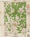
| Description: | Color map. "Topography by photogrammetric methods from aerial photographs taken 1963. Revised from aerial photographs taken 1978. Field checked 1979. Map e... |
| Date: | 1857 |
|---|---|
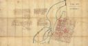
| Description: | This manuscript map is ink and watercolor on tracing cloth and shows bridges, lots, and streets. Some of the lots are in pink ink. The left of the map incl... |

| Date: | 1915 |
|---|---|
| Description: | This map is mounted on cloth and shows lots and landownership, selected buildings, roads, railroads, parks, cemeteries, city wards, and includes advertisem... |

| Date: | 1987 |
|---|---|
| Description: | This pictorial map shows roads, bridges, local businesses with phone numbers, and public buildings. Relief is shown pictorially. Also included is a calen... |

| Date: | 1899 |
|---|---|
| Description: | This map is ink on tracing cloth and shows lot and block numbers and dimensions, streets, the high school park, and survey monuments. The map is oriented ... |
| Date: | 1908 |
|---|---|
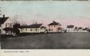
| Description: | Colorized view of a row of wood frame houses. Caption reads: "Residence Street, Edgar, Wis." |
| Date: | |
|---|---|
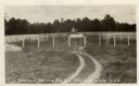
| Description: | View of the fox kennels at a fur farm. The main office is in the center of the fenced-in area. Caption reads: "Lemmer Fox and Fur Co., Marathon, Wis. U.S.A... |

| Date: | 1901 |
|---|---|
| Description: | A plat map of Marathon county, 28 township, north range, 7 east. |

| Date: | 1901 |
|---|---|
| Description: | A plat map of Marathon county, township 28, north range, 8 east. |

| Date: | 1901 |
|---|---|
| Description: | A plat map of Marathon county, township 29, north range, 6 east. |

| Date: | 1901 |
|---|---|
| Description: | A plat map of Marathon county, township 29, north range, 7 east. |

| Date: | 1901 |
|---|---|
| Description: | A plat map of Marathon county, township 29, north range, 8 east. |
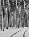
| Date: | 04 1962 |
|---|---|
| Description: | Tire tracks in fresh snow at Marathon park. The road is lined with snow-covered pines. |

| Date: | 05 01 1950 |
|---|---|
| Description: | Caption reads: "Citizens of Mosinee who could not show proper credentials were thrown into the stockade. Photo shows women pleading for food as armed guard... |

| Date: | 05 01 1950 |
|---|---|
| Description: | Caption on back reads: "All foodstuffs is confiscated by Red authorities and rationed to the citizens. Mrs. Delbert Bauer is shown as she gets her cup of P... |
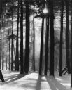
| Date: | 02 1976 |
|---|---|
| Description: | Picnic tables are propped against tall pine trees in snowy Marathon Park. The sun is sending rays of sunshine streaming through the trees. |
If you didn't find the material you searched for, our Library Reference Staff can help.
Call our reference desk at 608-264-6535 or email us at: