Filter: Categories of Wisconsin Historical Images
Filter: County of Marathon
Filter: Creator Name of Geological Survey
Filter: Categories of Wisconsin Historical Images
Filter: County of Marathon
Filter: Creator Name of Geological Survey

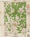
| Date: | 1982 |
|---|---|
| Description: | Color map. "Topography by photogrammetric methods from aerial photographs taken 1963. Revised from aerial photographs taken 1978. Field checked 1979. Map e... |
If you didn't find the material you searched for, our Library Reference Staff can help.
Call our reference desk at 608-264-6535 or email us at: