Filter: Categories of Wisconsin Historical Images
Filter: County of Marathon
Filter: Type of Map or Atlas
Filter: Subject of rivers
Filter: Categories of Wisconsin Historical Images
Filter: County of Marathon
Filter: Type of Map or Atlas
Filter: Subject of rivers

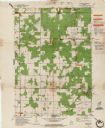
| Date: | 1943 |
|---|---|
| Description: | This photocopy map shows inhabited farms, rivers, roads, and mills in the vicinity of Marathon City [and village of Edgar], including area between the Big ... |

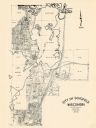
| Date: | 1965 |
|---|---|
| Description: | Map shows original plat, plat additions, and lot measurements for Rothschild, Wisconsin. Lake Wausau and the Wisconsin River are labelled. Map reads: "Comp... |
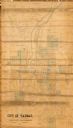
| Date: | 1892 |
|---|---|
| Description: | This map shows lot and block numbers and dimensions, some landownership, wards, railroads, streets, and mills. The map includes 5 plat additions that have ... |
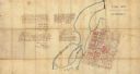
| Date: | 1965 |
|---|---|
| Description: | This map shows lot and block numbers and dimensions, additions, streets, and railroads. |
| Date: | 1857 |
|---|---|
| Description: | This manuscript map is ink and watercolor on tracing cloth and shows bridges, lots, and streets. Some of the lots are in pink ink. The left of the map incl... |

| Date: | 1987 |
|---|---|
| Description: | This pictorial map shows roads, bridges, local businesses with phone numbers, and public buildings. Relief is shown pictorially. Also included is a calen... |

| Date: | 1951 |
|---|---|
| Description: | This map shows land use, dwellings, resorts, camps, marshes, springs, dams, lake bottom composition, and access. The map includes a fish species table, geo... |

| Date: | 1901 |
|---|---|
| Description: | A plat map of Marathon county, 28 township, north range, 7 east. |

| Date: | 1901 |
|---|---|
| Description: | A plat map of Marathon county, township 28, north range, 8 east. |

| Date: | 1901 |
|---|---|
| Description: | A plat map of Marathon county, township 29, north range, 6 east. |

| Date: | 1901 |
|---|---|
| Description: | A plat map of Marathon county, township 29, north range, 7 east. |

| Date: | 1901 |
|---|---|
| Description: | A plat map of Marathon county, township 29, north range, 8 east. |
If you didn't find the material you searched for, our Library Reference Staff can help.
Call our reference desk at 608-264-6535 or email us at: