 Filter: Categories of Wisconsin Historical Images
Filter: County of Manitowoc
Filter: Year of 1900-1999
Filter: Categories of Wisconsin Historical Images
Filter: County of Manitowoc
Filter: Year of 1900-1999
| Date: | 1911 |
|---|---|
| Description: | Shows routes, post offices, schools, churches, houses, roads, and collection boxes of the rural delivery service of Manitowoc County. Bottom margins read:... |

| Date: | 1964 |
|---|---|
| Description: | This map of Two Rivers shows the Rodgers street fishing area and land use. The map features a legend on the right of the types of land use. The map also sh... |

| Date: | 1950 |
|---|---|
| Description: | Aerial view showing shipyards, rivers and roads. |
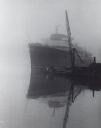
| Date: | 10 1962 |
|---|---|
| Description: | Lake steamer at dock, in fog. To the right is the boom of a crane. In front of the steamer is a tugboat. |

| Date: | 08 01 1958 |
|---|---|
| Description: | Two boys wearing hats with veils are working near a hive box near a small tree. A swarm of bees are on the ground near and on the hive box. One of the boys... |

| Date: | 1960 |
|---|---|
| Description: | This map is a cadastral map and shows block and lot numbers and dimensions, additions, streets, railroad, and Kiel Municipal Cemetery. The bottom right mar... |
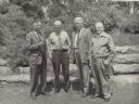
| Date: | 06 1958 |
|---|---|
| Description: | These four men from Wisconsin's Forests and Parks Department will retire in July 1958. C.L. (Neal) Harrington is second from the right. A new retirement ... |
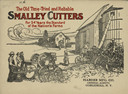
| Date: | 1911 |
|---|---|
| Description: | Front cover of catalog with the title: "The Old Time-Tried and Reliable Smalley Cutters. For 54 Years the Standard of the Nation's Farms." Features an illu... |

| Date: | 1910 |
|---|---|
| Description: | Three smiling women stand beside a horse-drawn carriage near Two Rivers. The horses are wearing knotted, corded fly nets and blinders. The carriage has a c... |
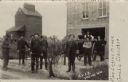
| Date: | 1910 |
|---|---|
| Description: | Photographic postcard of the Collins fire department volunteers, a fire wagon, the fire house and a nearby grain elevator. Caption reads: "C.V.F.D., Collin... |

| Date: | 1914 |
|---|---|
| Description: | St. James Church, shown intact before being destroyed by fire May 9th, 1914. Black and white, with blue sky color added to top of card. Caption reads: "St.... |

| Date: | 1914 |
|---|---|
| Description: | View towards the front and right side of the St. James School. Caption reads: "St. James School, Destroyed by Fire May 9, 1914. Cooperstown, Wis." |
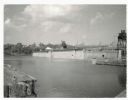
| Date: | 07 02 1960 |
|---|---|
| Description: | View across water towards the Manitowoc Shipbuilding floating drydock. Pilings and grass are in the foreground. On the far shoreline are buildings on a hil... |

| Date: | 01 08 1958 |
|---|---|
| Description: | Elevated view from 8th Street Bridge over the Manitowoc River towards Lake Michigan. There is a lighthouse in the distance. Ice is floating on the water. A... |

| Date: | 01 08 1958 |
|---|---|
| Description: | Elevated view over icy water towards ships in the shipyard on the left, and the cement company in the background. Cranes and industrial buildings are in th... |

| Date: | 01 08 1958 |
|---|---|
| Description: | View of Two Rivers Harbor from shoreline towards Lake Michigan. Snow is on the ground, and a fence made of thick posts and cable is along the shoreline on ... |

| Date: | 1905 |
|---|---|
| Description: | This map shows a plat of the city, local streets, railroads, public buildings, local businesses, and parts of the Manitowoc River and Lake Michigan. Relief... |

| Date: | 1925 |
|---|---|
| Description: | This map shows a plat of the city, local streets, railroads, public buildings, local businesses, and parts of the Manitowoc River and Lake Michigan. Relief... |
| Date: | 08 1964 |
|---|---|
| Description: | This map shows the city limits, Lake Michigan, the Manitowoc River, Silver Creek, designated sample sites with manuscript annotations, central business dis... |

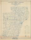
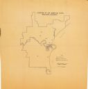
| Date: | 1903 |
|---|---|
| Description: | This map shows lakes, roads, railroads, townships, and land ownership by name. Counties are colored red, blue, or yellow. Lake Michigan is labeled. Also in... |
If you didn't find the material you searched for, our Library Reference Staff can help.
Call our reference desk at 608-264-6535 or email us at: