 Filter: Categories of Wisconsin Historical Images
Filter: County of Manitowoc
Filter: Year of 1900-1999
Filter: Type of Map or Atlas
Filter: Categories of Wisconsin Historical Images
Filter: County of Manitowoc
Filter: Year of 1900-1999
Filter: Type of Map or Atlas

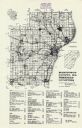
| Date: | 1947 |
|---|---|
| Description: | A map of Manitowoc County that shows the location and dates of seven pig fairs in the county; it also lists monthly pig and cattle sales in the surrounding... |
| Date: | 1976 |
|---|---|
| Description: | A map of Manitowoc County, Wisconsin, showing the location of 94 cemeteries in the county. The map also shows major roads that travel to the city of Manito... |
| Date: | 1955 |
|---|---|
| Description: | These 24 plat maps of the Town of Newton, Manitowoc County, Wisconsin, show soil type; mortgages in force as of January 1, 1932; land warrants holders; mor... |
| Date: | 1945 |
|---|---|
| Description: | Map features a legend with symbols of points of interest. The symbols are in red. The back of the map has text on "Points of Interest and Information". |

| Date: | 1951 |
|---|---|
| Description: | Water depths shown by bathymetric tints, isolines, and soundings. Relief shown by contours. "Soundings in feet." "Aids to navigation corrected to May 4, 19... |
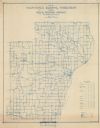
| Date: | 1911 |
|---|---|
| Description: | Shows routes, post offices, schools, churches, houses, roads, and collection boxes of the rural delivery service of Manitowoc County. Bottom margins read:... |

| Date: | 1964 |
|---|---|
| Description: | This map of Two Rivers shows the Rodgers street fishing area and land use. The map features a legend on the right of the types of land use. The map also sh... |

| Date: | 1960 |
|---|---|
| Description: | This map is a cadastral map and shows block and lot numbers and dimensions, additions, streets, railroad, and Kiel Municipal Cemetery. The bottom right mar... |

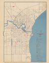
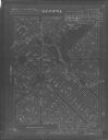
| Date: | 1905 |
|---|---|
| Description: | This map shows a plat of the city, local streets, railroads, public buildings, local businesses, and parts of the Manitowoc River and Lake Michigan. Relief... |

| Date: | 1925 |
|---|---|
| Description: | This map shows a plat of the city, local streets, railroads, public buildings, local businesses, and parts of the Manitowoc River and Lake Michigan. Relief... |
| Date: | 08 1964 |
|---|---|
| Description: | This map shows the city limits, Lake Michigan, the Manitowoc River, Silver Creek, designated sample sites with manuscript annotations, central business dis... |

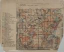
| Date: | 1903 |
|---|---|
| Description: | This map shows lakes, roads, railroads, townships, and land ownership by name. Counties are colored red, blue, or yellow. Lake Michigan is labeled. Also in... |

| Date: | 1926 |
|---|---|
| Description: | This blueprint map shows the land and its uses near Two Rivers Harbor. Lake Michigan is labeled on the left. Roads and buildings are also labeled. Original... |
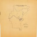
| Date: | 1900 |
|---|---|
| Description: | This map shows a paper city located in section 23, township 17 north, range 22 east; area now occupied by the community of Spring Valley in Manitowoc Count... |
| Date: | 1900 |
|---|---|
| Description: | Map shows a paper city located in Manitowoc County, on the (unlabeled) Devils River. Includes land parcels, blocks, and street names. The back of the map i... |

| Date: | 1926 |
|---|---|
| Description: | This blueprint map shows Manitowoc Harbor with depths represented by soundings. The upper right corner includes a "Description of Bench Marks". The map als... |
| Date: | 1900 |
|---|---|
| Description: | This photocopy map shows the village in sections 23 and 24 of T19, R23E; later this area became part of the city of Manitowoc. The back of the map includes... |

| Date: | 1951 |
|---|---|
| Description: | This map shows city streets, zoning of city areas, residences, local businesses, and commercial areas marked in red, yellow, and light brown. The bottom ri... |
If you didn't find the material you searched for, our Library Reference Staff can help.
Call our reference desk at 608-264-6535 or email us at: