 Filter: Categories of Wisconsin Historical Images
Filter: County of Manitowoc
Filter: Year of 1800-1899
Filter: Year of 1860-1869
Filter: Categories of Wisconsin Historical Images
Filter: County of Manitowoc
Filter: Year of 1800-1899
Filter: Year of 1860-1869

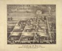
| Date: | 1868 |
|---|---|
| Description: | Bird's-eye map of Manitowoc, with four insets. Manitowoc County. |
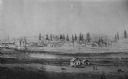
| Date: | 1860 |
|---|---|
| Description: | Elevated view of the Roman Catholic community of St. Nazianz. |
| Date: | 1860 |
|---|---|
| Description: | Ansicht Von St Nanianz, gregundet vom Jahr 1854 bis 1860. Sr. Hochw. Hern V. Oschald. n.p., n.d. |

| Date: | 1865 |
|---|---|
| Description: | This map shows the river shore and piers. Lake Michigan is labeled. Depths are shown by soundings and isolines. The bottom margin includes notes on soundi... |
If you didn't find the material you searched for, our Library Reference Staff can help.
Call our reference desk at 608-264-6535 or email us at: