 Filter: Categories of Wisconsin Historical Images
Filter: County of Manitowoc
Filter: Year of 1800-1899
Filter: Categories of Wisconsin Historical Images
Filter: County of Manitowoc
Filter: Year of 1800-1899
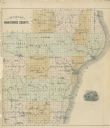
| Date: | 1878 |
|---|---|
| Description: | Outline map of Manitowoc County. Includes engraving of Wisconsin State Seal at bottom right. |

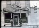
| Date: | 1898 |
|---|---|
| Description: | The storefront of Nicholas Kettenhoffen's "Graves Stones & Markers." Three men are standing in front of the store with three large grave markers. |
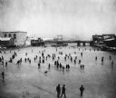
| Date: | 1888 |
|---|---|
| Description: | Elevated view of a winter scene with a large group of people skating on the frozen Manitowoc River between the 8th and 10th Street bridges. A dog trots acr... |
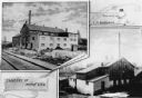
| Date: | 1891 |
|---|---|
| Description: | Composite photograph showing the tanneries of L.M. Sherman and Henry Vits. |
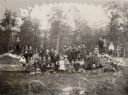
| Date: | 1892 |
|---|---|
| Description: | Group of schoolchildren posed sitting and standing on a fallen tree trunk. They are dressed in their finest clothes for a school photograph. One of the boy... |
| Date: | 1895 |
|---|---|
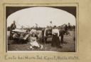
| Description: | Women bringing lunch to the men working in the field. The men are harvesting grain using a horse-drawn grain binder. |
| Date: | 1891 |
|---|---|
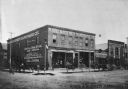
| Description: | Exterior view of Schuette Brothers Store on S. Eighth Street. There are two horse-drawn vehicles in front of the store. There is a small mannequin in the s... |
| Date: | 1888 |
|---|---|
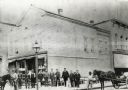
| Description: | Men who worked for Schuette Brothers Store assembled in front of the store. There are horses on both sides of the photograph, and the one on the right is p... |
| Date: | 1891 |
|---|---|
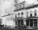
| Description: | Exterior view from street of Rand & Roemer Hardware Co. and Henry Hinrich's Drug Store. Also visible are Rand & Roemer Ship Chandlery (nautical supply), Ra... |
| Date: | 1898 |
|---|---|
| Description: | Two older men and one younger man standing on a boardwalk in front of the Atlantic Saloon owned by C.J. Vogel. A hanging sign to the right advertises for S... |

| Date: | 1800 |
|---|---|
| Description: | This 19th-century manuscript map of the Town of Newton, Manitowoc County, Wisconsin, shows sections, lakes and streams, the trail from Chicago to Green Bay... |

| Date: | 01 1899 |
|---|---|
| Description: | Shows lot and block numbers, railroads, ward boundaries, and some landownership. Includes public building index. |

| Date: | 1872 |
|---|---|
| Description: | Shows townships and sections, landownership and acreages, roads, railroads, churches, schools, and cemeteries. Includes business directories of Manitowoc ... |

| Date: | 1875 |
|---|---|
| Description: | This map oriented with the north to the upper left is ink, mounted on clothe. The depths of the water are shown by soundings. A handwritten inscription on ... |

| Date: | 1810 |
|---|---|
| Description: | This map shows lot and block numbers, streets, and the public square. The bottom right margin reads: "Robert M. Eberts, Henry S. Baird, A.G. Ellis, R.S. Sa... |

| Date: | 1856 |
|---|---|
| Description: | This map shows the Manitowoc River, Lake Michigan, streets, and buildings. Relief is shown by hachures and soundings are in feet and decimals of a foot. Th... |

| Date: | 09 1853 |
|---|---|
| Description: | This map shows streets, docks, warehouses, and piers near the harbor. The Manitowoc River and Lake Michigan are labeled. Depths are indicated by soundings ... |

| Date: | 1854 |
|---|---|
| Description: | This map shows streets, docks, warehouses, and piers near the harbor. Relief is shown by hachures and depths are shown by soundings and isolines. Lake Mich... |

| Date: | 1856 |
|---|---|
| Description: | This map shows streets, piers, and wharves. Lake Michigan, the Manitowoc River, and select buildings are labeled. Relief is shown by hachures and sounding... |

| Date: | 1865 |
|---|---|
| Description: | This map shows the river shore and piers. Lake Michigan is labeled. Depths are shown by soundings and isolines. The bottom margin includes notes on soundi... |
If you didn't find the material you searched for, our Library Reference Staff can help.
Call our reference desk at 608-264-6535 or email us at: