 Filter: Categories of Wisconsin Historical Images
Filter: County of Manitowoc
Filter: Subject of cities and towns
Filter: Categories of Wisconsin Historical Images
Filter: County of Manitowoc
Filter: Subject of cities and towns

| Date: | 1800 |
|---|---|
| Description: | This 19th-century manuscript map of the Town of Newton, Manitowoc County, Wisconsin, shows sections, lakes and streams, the trail from Chicago to Green Bay... |
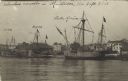
| Date: | 09 06 1913 |
|---|---|
| Description: | Postcard view across water towards reproductions of Christopher Columbus' ships, the Niña, Pinta, and the Santa Maria docked at Manito... |

| Date: | 1961 |
|---|---|
| Description: | Patricia Mullins (3rd from right) and her Mariner Scout Troop pose outdoors. |
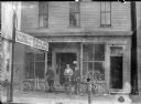
| Date: | 1900 |
|---|---|
| Description: | View from street of three men standing with bicycles in front of Frank Sladek's bicycle shop. A sign at left indicates that Sladek's shop custom built and ... |
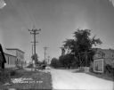
| Date: | 1924 |
|---|---|
| Description: | View down unpaved street of a large store on the left with three cars parked in front, near an ice cream signboard. There is a house with a balcony in the ... |
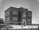
| Date: | 1924 |
|---|---|
| Description: | View of the front of the public school, a three-story brick building. Wooden buildings are in the background on the left. In the foreground is a barbed wir... |
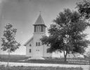
| Date: | 1924 |
|---|---|
| Description: | View across road towards the church which has wood clapboard siding, arched windows, arched double front doors, and a three-sided set of stairs leading to ... |

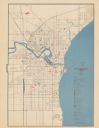
| Date: | 01 1899 |
|---|---|
| Description: | Shows lot and block numbers, railroads, ward boundaries, and some landownership. Includes public building index. |
| Date: | 1945 |
|---|---|
| Description: | Map features a legend with symbols of points of interest. The symbols are in red. The back of the map has text on "Points of Interest and Information". |

| Date: | 1951 |
|---|---|
| Description: | Water depths shown by bathymetric tints, isolines, and soundings. Relief shown by contours. "Soundings in feet." "Aids to navigation corrected to May 4, 19... |

| Date: | 1872 |
|---|---|
| Description: | Shows townships and sections, landownership and acreages, roads, railroads, churches, schools, and cemeteries. Includes business directories of Manitowoc ... |

| Date: | 1964 |
|---|---|
| Description: | This map of Two Rivers shows the Rodgers street fishing area and land use. The map features a legend on the right of the types of land use. The map also sh... |

| Date: | 1950 |
|---|---|
| Description: | Aerial view showing shipyards, rivers and roads. |

| Date: | 1960 |
|---|---|
| Description: | This map is a cadastral map and shows block and lot numbers and dimensions, additions, streets, railroad, and Kiel Municipal Cemetery. The bottom right mar... |
| Date: | 1910 |
|---|---|
| Description: | Photographic postcard of the Collins fire department volunteers, a fire wagon, the fire house and a nearby grain elevator. Caption reads: "C.V.F.D., Collin... |

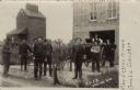
| Date: | 1914 |
|---|---|
| Description: | St. James Church, shown intact before being destroyed by fire May 9th, 1914. Black and white, with blue sky color added to top of card. Caption reads: "St.... |

| Date: | 1914 |
|---|---|
| Description: | View towards the front and right side of the St. James School. Caption reads: "St. James School, Destroyed by Fire May 9, 1914. Cooperstown, Wis." |

| Date: | 1810 |
|---|---|
| Description: | This map shows lot and block numbers, streets, and the public square. The bottom right margin reads: "Robert M. Eberts, Henry S. Baird, A.G. Ellis, R.S. Sa... |

| Date: | 01 08 1958 |
|---|---|
| Description: | Elevated view over icy water towards ships in the shipyard on the left, and the cement company in the background. Cranes and industrial buildings are in th... |

| Date: | 1905 |
|---|---|
| Description: | This map shows a plat of the city, local streets, railroads, public buildings, local businesses, and parts of the Manitowoc River and Lake Michigan. Relief... |
If you didn't find the material you searched for, our Library Reference Staff can help.
Call our reference desk at 608-264-6535 or email us at: