 Filter: Categories of Wisconsin Historical Images
Filter: County of Manitowoc
Filter: Subject of cemeteries
Filter: Categories of Wisconsin Historical Images
Filter: County of Manitowoc
Filter: Subject of cemeteries
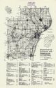
| Date: | 1976 |
|---|---|
| Description: | A map of Manitowoc County, Wisconsin, showing the location of 94 cemeteries in the county. The map also shows major roads that travel to the city of Manito... |

| Date: | 1872 |
|---|---|
| Description: | Shows townships and sections, landownership and acreages, roads, railroads, churches, schools, and cemeteries. Includes business directories of Manitowoc ... |

| Date: | 1960 |
|---|---|
| Description: | This map is a cadastral map and shows block and lot numbers and dimensions, additions, streets, railroad, and Kiel Municipal Cemetery. The bottom right mar... |

| Date: | |
|---|---|
| Description: | This plat map shows numbered blocks and lots, wards, local streets, railroads, cemeteries, buildings, land ownership by name, and parts of Manitowoc River ... |
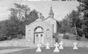
| Date: | 1935 |
|---|---|
| Description: | The tomb of Rev. Ambrose Oschwald (1801-1873), faced with fieldstone, is built into the hillside behind the Loretto chapel at St. Nazianz cemetery. White ... |
If you didn't find the material you searched for, our Library Reference Staff can help.
Call our reference desk at 608-264-6535 or email us at: