 Filter: Categories of Wisconsin Historical Images
Filter: County of Manitowoc
Filter: Subject of architecture
Filter: Categories of Wisconsin Historical Images
Filter: County of Manitowoc
Filter: Subject of architecture
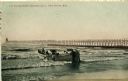
| Date: | 1908 |
|---|---|
| Description: | Group of men on a life saving crew launching a rowboat into Lake Michigan. A long pier with a lighthouse at the end bisects the horizon. Caption reads: "Li... |
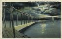
| Date: | 1927 |
|---|---|
| Description: | Hand-colored postcard view of a pier and lighthouse at night. The moon shines through clouds, and light shines in two directions from the beacon on top of ... |
| Date: | 1934 |
|---|---|
| Description: | Malt kiln fire boxes, Rahr Malting Company, Manitowoc, Wisconsin, 1934. These fireboxes heated Rahr's double-decked malt kiln, in which the hot exhaust air... |
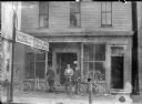
| Date: | 1900 |
|---|---|
| Description: | View from street of three men standing with bicycles in front of Frank Sladek's bicycle shop. A sign at left indicates that Sladek's shop custom built and ... |
| Date: | 1924 |
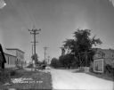
|---|---|
| Description: | View down unpaved street of a large store on the left with three cars parked in front, near an ice cream signboard. There is a house with a balcony in the ... |
| Date: | 1924 |
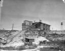
|---|---|
| Description: | View from low section of quarry towards the processing plant up a steep rise. Tracks for hauling limestone are on the left near small sheds and a marshy ar... |
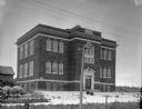
| Date: | 1924 |
|---|---|
| Description: | View of the front of the public school, a three-story brick building. Wooden buildings are in the background on the left. In the foreground is a barbed wir... |
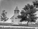
| Date: | 1924 |
|---|---|
| Description: | View across road towards the church which has wood clapboard siding, arched windows, arched double front doors, and a three-sided set of stairs leading to ... |

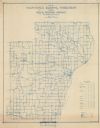
| Date: | 1872 |
|---|---|
| Description: | Shows townships and sections, landownership and acreages, roads, railroads, churches, schools, and cemeteries. Includes business directories of Manitowoc ... |
| Date: | 1911 |
|---|---|
| Description: | Shows routes, post offices, schools, churches, houses, roads, and collection boxes of the rural delivery service of Manitowoc County. Bottom margins read:... |
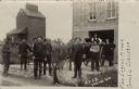
| Date: | 1910 |
|---|---|
| Description: | Photographic postcard of the Collins fire department volunteers, a fire wagon, the fire house and a nearby grain elevator. Caption reads: "C.V.F.D., Collin... |

| Date: | 1914 |
|---|---|
| Description: | St. James Church, shown intact before being destroyed by fire May 9th, 1914. Black and white, with blue sky color added to top of card. Caption reads: "St.... |

| Date: | 01 08 1958 |
|---|---|
| Description: | Elevated view from 8th Street Bridge over the Manitowoc River towards Lake Michigan. There is a lighthouse in the distance. Ice is floating on the water. A... |

| Date: | 01 08 1958 |
|---|---|
| Description: | View of Two Rivers Harbor from shoreline towards Lake Michigan. Snow is on the ground, and a fence made of thick posts and cable is along the shoreline on ... |

| Date: | 1875 |
|---|---|
| Description: | Team of oxen pulling a wagon in front of Schuette Brothers store grain warehouse on a muddy Jay Street. The man standing with the oxen is likely Fred Wilke... |
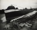
| Date: | 09 09 1954 |
|---|---|
| Description: | Elevated view of the sideways launching of Hull 418, the Detroit Edison at Manitowoc Shipbuilding, Inc. A group of people are gathered at the wharf ... |

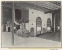
| Date: | 10 07 1911 |
|---|---|
| Description: | Interior group portrait of horticulture exhibitors and many plates of apples. The ceiling lamps are decorated with flags. |

| Date: | 1870 |
|---|---|
| Description: | This blueprint map shows lot and block numbers, streets, and right of way for the Two Rivers Branch railroad. The map covers land west to sections 22 and 2... |

| Date: | 1926 |
|---|---|
| Description: | This blueprint map shows the land and its uses near Two Rivers Harbor. Lake Michigan is labeled on the left. Roads and buildings are also labeled. Original... |

| Date: | 1926 |
|---|---|
| Description: | This blueprint map shows Manitowoc Harbor with depths represented by soundings. The upper right corner includes a "Description of Bench Marks". The map als... |
If you didn't find the material you searched for, our Library Reference Staff can help.
Call our reference desk at 608-264-6535 or email us at: