 Filter: Categories of Wisconsin Historical Images
Filter: County of Manitowoc
Filter: Community of Kiel
Filter: Subject of transportation
Filter: Categories of Wisconsin Historical Images
Filter: County of Manitowoc
Filter: Community of Kiel
Filter: Subject of transportation

| Date: | 1960 |
|---|---|
| Description: | This map is a cadastral map and shows block and lot numbers and dimensions, additions, streets, railroad, and Kiel Municipal Cemetery. The bottom right mar... |
| Date: | |
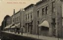
|---|---|
| Description: | Photographic postcard view of a city block lined with businesses on the right. The State Bank is in the foreground on the right, and a restaurant is next d... |
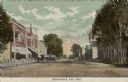
| Date: | 1910 |
|---|---|
| Description: | Colorized postcard view down center of unpaved Main Street. There is a block of businesses with awnings on the left. Horse-drawn vehicles are parked at hit... |
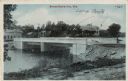
| Date: | 08 1916 |
|---|---|
| Description: | View of a bridge over the Sheboygan River. There are lampposts on each corner of the bridge, indicated by arrows. Caption reads: "Bridge Scene, Kiel, Wis." |
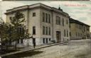
| Date: | 1910 |
|---|---|
| Description: | Colorized postcard view across street towards the brick high school on the left. A group of students are on the sidewalk outside of the entrance, and a man... |
If you didn't find the material you searched for, our Library Reference Staff can help.
Call our reference desk at 608-264-6535 or email us at: