 Filter: Categories of Wisconsin Historical Images
Filter: County of Manitowoc
Filter: Creator Name of Unknown
Filter: Subject of transportation
Filter: Categories of Wisconsin Historical Images
Filter: County of Manitowoc
Filter: Creator Name of Unknown
Filter: Subject of transportation
| Date: | 05 10 1942 |
|---|---|
| Description: | USS "Peto" (SS-265), a Gato-class submarine, was a ship of the United States Navy named for the peto, a sharp-nosed tropical fish of the mackerel family. "... |

| Date: | |
|---|---|
| Description: | Exterior view of two buildings which comprise Holy Family Hospital. |

| Date: | |
|---|---|
| Description: | Letterhead of the William Rahr Sons' Company of Manitowoc, Wisconsin, "Maltsters and Roasters," with an elevated view of the company building on one side o... |

| Date: | 1962 |
|---|---|
| Description: | View across road towards loading dock of the Kingsbury Brewing Company. Printed on the side of the building are two advertisements for Kingsbury Beer. |
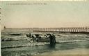
| Date: | 1908 |
|---|---|
| Description: | Group of men on a life saving crew launching a rowboat into Lake Michigan. A long pier with a lighthouse at the end bisects the horizon. Caption reads: "Li... |

| Date: | 1800 |
|---|---|
| Description: | This 19th-century manuscript map of the Town of Newton, Manitowoc County, Wisconsin, shows sections, lakes and streams, the trail from Chicago to Green Bay... |
| Date: | 09 06 1913 |
|---|---|
| Description: | Postcard view across water towards reproductions of Christopher Columbus' ships, the Niña, Pinta, and the Santa Maria docked at Manito... |

| Date: | 1961 |
|---|---|
| Description: | Patricia Mullins (3rd from right) and her Mariner Scout Troop pose outdoors. |

| Date: | 1950 |
|---|---|
| Description: | Aerial view showing shipyards, rivers and roads. |

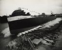
| Date: | 01 08 1958 |
|---|---|
| Description: | Elevated view from 8th Street Bridge over the Manitowoc River towards Lake Michigan. There is a lighthouse in the distance. Ice is floating on the water. A... |

| Date: | 01 08 1958 |
|---|---|
| Description: | Elevated view over icy water towards ships in the shipyard on the left, and the cement company in the background. Cranes and industrial buildings are in th... |

| Date: | 1856 |
|---|---|
| Description: | This map shows the Manitowoc River, Lake Michigan, streets, and buildings. Relief is shown by hachures and soundings are in feet and decimals of a foot. Th... |

| Date: | 09 1853 |
|---|---|
| Description: | This map shows streets, docks, warehouses, and piers near the harbor. The Manitowoc River and Lake Michigan are labeled. Depths are indicated by soundings ... |

| Date: | 1856 |
|---|---|
| Description: | This map shows streets, piers, and wharves. Lake Michigan, the Manitowoc River, and select buildings are labeled. Relief is shown by hachures and sounding... |

| Date: | 1865 |
|---|---|
| Description: | This map shows the river shore and piers. Lake Michigan is labeled. Depths are shown by soundings and isolines. The bottom margin includes notes on soundi... |

| Date: | 1874 |
|---|---|
| Description: | This map shows piers, streets, the Manitowoc River and shore lines of 1856, 1869, 1873 and 1874. The top margin reads; "Soundings taken 1974." Written in i... |

| Date: | 1903 |
|---|---|
| Description: | This map shows lakes, roads, railroads, townships, and land ownership by name. Counties are colored red, blue, or yellow. Lake Michigan is labeled. Also in... |
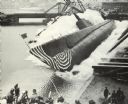
| Date: | 09 09 1954 |
|---|---|
| Description: | Elevated view of the sideways launching of Hull 418, the Detroit Edison at Manitowoc Shipbuilding, Inc. A group of people are gathered at the wharf ... |
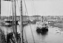
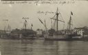
| Date: | |
|---|---|
| Description: | Elevated view of commercial boats in Manitowoc Harbor. |

| Date: | 1870 |
|---|---|
| Description: | This blueprint map shows lot and block numbers, streets, and right of way for the Two Rivers Branch railroad. The map covers land west to sections 22 and 2... |
If you didn't find the material you searched for, our Library Reference Staff can help.
Call our reference desk at 608-264-6535 or email us at: